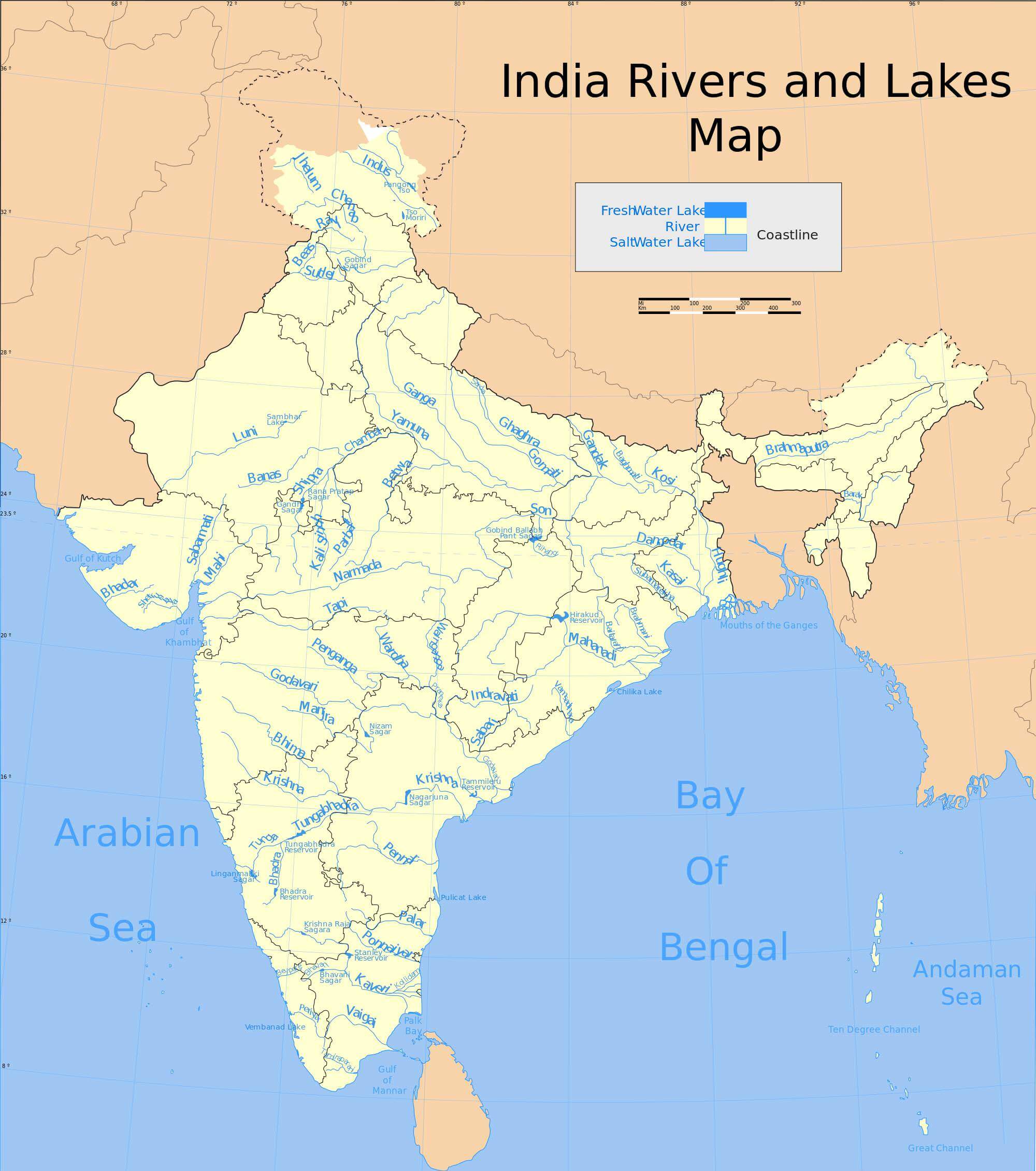
(Unit 3-Topic 3) West Flowing & East Flowing Peninsular Rivers
Indian Geography (Unit 3-Topic 3)
West Flowing Peninsular Rivers
West Flowing Peninsular Rivers: Narmada, Tapti, Sabarmati, Mahi, Luni & Ghaggar
West Flowing Rivers of The Peninsular India
- The west flowing rivers of the Peninsular India are fewer and smaller as compared to their east flowing counterparts.
- The two major west flowing rivers are the Narmada and the Tapi.
- This exceptional behavior is because these rivers didn’t form valleys and instead they flow through faults (linear rift, rift valley, trough) created due to the bending of the northern peninsula during the formation process of Himalayas.
- These faults run parallel to the Vindhyas and the Satpuras.
- The Sabarmati, Mahi and Luni are other rivers of the Peninsular India which flow westwards.
- Hundreds of small streams originating in the Western Ghats flow swiftly westwards and join the Arabian Sea.
- It is interesting to note that the Peninsular rivers which fall into the Arabian Sea do not form deltas, but only estuaries. {Fluvial Depositional Landforms}
- This is due to the fact that the west flowing rivers, especially the Narmada and the Tapi flow through hard rocks and hence do not carry any good amount of silt.
- Moreover, the tributaries of these rivers are very small and hence they don’t contribute any silt.
- Hence these rivers are not able to form distributaries or a delta before they enter the sea.
Estuary
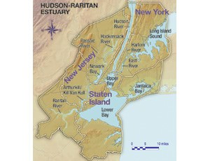
- An estuary is a partially enclosed body of water along the coast where freshwater from rivers and streams meets and mixes with salt water from the ocean. [Primary productivity in estuaries is very high. Fishing is a dominant occupation around estuaries. Most of the estuaries are good bird sanctuaries].
- Estuaries and the lands surrounding them are places of transition from land to sea and freshwater to salt water.
- Although influenced by the tides, they are protected from the full force of ocean waves, winds, and storms by such land forms as barrier islands or peninsulas. [You know why estuaries make good ports?]
- Estuarine environments are among the most productive on earth, creating more organic matter each year than comparably-sized areas of forest, grassland, or agricultural land.
- The tidal, sheltered waters of estuaries also support unique communities of plants and animals especially adapted for life at the margin of the sea.
- Estuaries have important commercial value and their resources provide economic benefits for tourism, fisheries, and recreational activities.
- The protected coastal waters of estuaries also support important public infrastructure, serving as harbors and ports vital for shipping and transportation.
- Estuaries also perform other valuable services. Water draining from uplands carries sediments, nutrients, and other pollutants to estuaries. As the water flows through wetlands such as swamps and salt marshes, much of the sediments and pollutants are filtered out.
- Salt marsh grasses and other estuarine plants also help prevent erosion and stabilize shorelines [Mangroves].
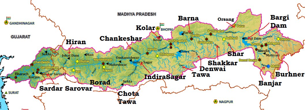
Narmada River
- Narmada is the largest west flowing river of the peninsular India.
- Narmada flows westwards through a rift valley between the Vindhyan Range on the north and the Satpura Range on the south.
- It rises from Maikala range near Amarkantak in Madhya Pradesh, at an elevation of about 1057 m.
- Narmada basin extends over states of Madhya Pradesh, Gujarat, Maharashtra and Chhattisgarh having an area ~1 Lakh Sq.km.
- It is bounded by the Vindhyas on the north, Maikala range on the east, Satpuras on the south and by the Arabian Sea on the west.
- Its total length from its source in Amarkantak to its estuary in the Gulf of Khambhat is 1,310 km.
- The hilly regions are in the upper part of the basin, and lower middle reaches are broad and fertile areas well suited for cultivation.
- Jabalpur is the only important urban centre in the basin.
- The river slopes down near Jabalpur where it cascades (a small waterfall, especially one in a series) 15 m into a gorge to form the Dhuan Dhar (Cloud of Mist) Falls.
- Since the gorge is composed of marble, it is popularly known as the Marble Rocks.
- It makes two waterfalls of 12 m each at Mandhar and Dardi. Near Maheshwar the river again descends from another small fall of 8 m, known as the Sahasradhara Falls.
- There are several islands in the estuary of the Narmada of which Aliabet is the largest.
- The Narmada is navigable upto 112 km from its mouth.
Tributaries of Narmada River
- Since the river flows through a narrow valley confined by precipitous (dangerously high or steep) hills, it does not have many tributaries.
- The absence of tributaries is especially noted on the right bank of the river where the Hiran is the only exception.
- The other right bank tributaries are the Orsang, the Barna and the Kolar.
- A few left bank tributaries drain the northern slopes of the Satpura Range and join the Narmada at different places.
- The major Hydro Power Project in the basin are Indira Sagar, Sardar Sarovar, Omkareshwar, Bargi & Maheshwar.
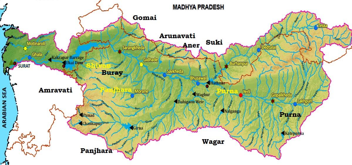
Tapti River
- The Tapti (also known as the Tapi) is the second largest west flowing river of the Peninsular India and is known as ‘the twin’ or ‘the handmaid’ of the Narmada.
- It originates near Multai reserve forest in Madhya Pradesh at an elevation of 752 m.
- Flows for about 724 km before outfalling into the Arabian Sea through the Gulf of Cambay [Gulf of Khambhat].
- The Tapti River along with its tributaries flows over the plains of Vidharbha, Khandesh and Gujarat and over large areas in the state of Maharashtra and a small area in Madhya Pradesh and Gujarat.
- The basin extends over states of Madhya Pradesh, Maharashtra and Gujarat having an area of ~ 65,000 Sq.km
- Situated in the Deccan plateau, the basin is bounded by the Satpura range on the north, Mahadev hills on the east, Ajanta Range and the Satmala hills on the south and by the Arabian Sea on the west.
- The hilly region of the basin is well forested while the plains are broad and fertile areas suitable for cultivation.
- There are two well defined physical regions, in the basin, viz hilly region and plains; the hilly regions comprising Satpura, Satmalas, Mahadeo, Ajanta and Gawilgarh hills are well forested.
- The plain covers the Khandesh areas (Khandesh is a region of central India, which forms the northwestern portion of Maharashtra state) which are broad and fertile suitable for cultivation primarily.
Tributaries of Tapti River
- Right Bank: the Suki, the Gomai, the Arunavati and the Aner.
- Left Bank: the Vaghur, the Amravati, the Buray, the Panjhra, the Bori, the Girna, the Purna, the Mona and the Sipna.
Projects on Tapti River
- Hathnur Dam of Upper Tapi Project (Maharashtra)
- Kakrapar weir and Ukai Dam of Ukai Project (Gujarat)
- Girna Dam and Dahigam Weir of Girna Project (Maharashtra)
Industry in the Tapti Basin
- Important industries in the basin are textile factories in Surat and paper and news print factory at Nepanagar.
Sabarmati River
- The Sabarmati is the name given to the combined streams the Sabar and Hathmati.
- The Sabarmati basin extends over states of Rajasthan and Gujarat having an area of 21,674 Sq km.
- The basin is bounded by Aravalli hills on the north and north-east, by Rann of Kutch on the west and by Gulf of Khambhat on the south.
- The basin is roughly triangular in shape with the Sabarmati River as the base and the source of the Vatrak River as the apex point.
- Sabarmati originates from Aravalli hills at an elevation of 762 m near village Tepur, in Udaipur district of Rajasthan.
- The total length of river from origin to outfall into the Arabian Sea is 371 km.
- The major part of basin is covered with agriculture accounting to 74.68% of the total area.
- Rainfall varies from a meager few mm in Saurastra to over 1000 mm in southern part.
- Left bank tributaries: the Wakal, the Hathmati and the Vatrak.
- Right bank tributaries: the Sei.
- Projects: Sabarmati reservoir (Dharoi), Hathmati reservoir and Meshwo reservoir project are major projects completed during the plan period.
- Gandhinagar and Ahmedabad are the important urban centers in the basin.
- Ahmedabad is an industrial city situated on the banks of Sabarmati.
- Important industries are textiles, leather and leather goods, plastic, rubber goods, paper, newsprint, automobile, machine tools, drugs and pharmaceuticals etc.
- The industrial city of Ahmedabad poses the danger of water pollution.
Mahi River
- The Mahi basin extends over states of Madhya Pradesh, Rajasthan and Gujarat having total area of 34,842 Sq km.
- It is bounded by Aravalli hills on the north and the north-west, by Malwa Plateau on the east, by the Vindhyas on the south and by the Gulf of Khambhat on the west.
- Mahi is one of the major interstate west flowing rivers of India.
- It originates from the northern slopes of Vindhyas at an altitude of 500 m in Dhar district of Madhya Pradesh.
- The total length of Mahi is 583 km.
- It drains into the Arabian Sea through the Gulf of Khambhat.
- The major part of basin is covered with agricultural land accounting to 63.63% of the total area
- Hydro Power stations are located in Mahi Bajaj Sagar dam and at Kadana Dam.
- Vadodara is the only important urban centre in the basin. There are not many industries in the basin.
- Some of the industries are cotton textile, paper, newsprint, drugs and pharmaceuticals. Most of these industries are located at Tatlam.
Luni River
- The Luni or the Salt River (Lonari or Lavanavari in Sanskrit) is named so because its water is brackish below Balotra.
- Luni is the only river basin of any significance in Western Rajasthan, which form the bulk of arid zone.
- Luni originates from western slopes of the Aravalli ranges at an elevation of 772 m near Ajmerflowing in South West direction and traversing a course of 511 km in Rajasthan, it finally flow into the Rann of Kachchh (it gets lost in the marsh).
- Most of its tributaries drain the steep north west of Aravalli hills and join it on left side. Its total catchment area falls in Rajasthan.
- The peculiarity of this river is that it tends to increase its width rather than deepening the bed because the banks are of soils, which are easily erodible whereas beds are of sand. The floods develop and disappear so rapidly that they have no time to scour the bed.
West flowing Rivers of the Sahyadris (Western Ghats)
- About six hundred small streams originate from the Western Ghats and flow westwards to fall into the Arabian Sea.
- The western slopes of the Western Ghats receive heavy rainfall from the south-west monsoons and are able to feed such a large number of streams.
- Although only about 3% of the areal extent flow swiftly down the steep slope and some of them make waterfalls.
- The Jog or Gersoppa Falls (289 m) made by the Sharavati river is the most famous waterfall of India.
Ghaggar River – Inland Drainage
- Some rivers of India are not able to reach the sea and constitute inland drainage.
- Large parts of the Rajasthan desert and parts of Aksai Chin in Ladakh have inland drainage.
- The Ghaggar is the most important river of inland drainage. It is a seasonal stream which rises on the lower slopes of the Himalayas and forms boundary between Haryana and Punjab.
- It gets lost in the dry sands of Rajasthan near Hanumangarh after traversing a distance of 465 km.
- Earlier, this river was an affluent of the Indus, the dry bed of the old channel is still traceable.
- Its main tributaries are the Tangri, the Markanda, the Saraswati and the Chaitanya.
- It contains a lot more water in rainy season when its bed becomes 10 km wide at places.
- Most of the streams draining western slopes of the Aravalli Range dry up immediately after they enter the sandy arid areas to the west of this range.
Usability of Rivers
- Source of fresh water, irrigation, hydro-electric production, navigation etc.
- The Himalayas, Vindhyas, Satpuras, Aravalis, Maikala, Chhotanagpur plateau, Meghalaya plateau, Purvachal, Western and the Eastern Ghats offer possibilities of large scale water power development.
- Sixty per cent of the total river flow is concentrated in the Himalayan rivers, 16 per cent in the Central Indian rivers (the Narmada, the Tapi, the Mahanadi, etc.), and the rest in the rivers of the Deccan plateau.
- The Ganga and the Brahmaputra in the north and northeastern part of the country, the Mahanadi in Odisha, the Godavari and the Krishna in Andhra and Telangana the Narmada and the Tapi in Gujarat, and the lakes and tidal creeks in coastal states possess some of the important and useful waterways of the country.
- In the past they were of great importance, which suffered a great deal with the advent of rail and roads.
- Withdrawal of large quantities of water for irrigation resulted in dwindling flow of many rivers.
- The most important navigable risers are the Ganga, the Brahmaputra and the Mahanadi. The Godavari, the Krishna, the Narmada and the Tapi are navigable near their mouths only.
______________________________________________________________________
East Flowing Peninsular Rivers
East Flowing Peninsular Rivers: Godavari, Krishna & Mahanadi
East Flowing Peninsular Rivers
- Mahanadi River
- Godavari River
- Krishna River
- Kaveri (Cauvery) River
- Pennar River
- Subarnarekha River
- Brahamani River
- Sarada River
- Ponnaiyar River
- Vaigai River
Mahanadi River
- The Mahanadi basin extends over states of Chhattisgarh and Odisha and comparatively smaller portions of Jharkhand, Maharashtra and Madhya Pradesh, draining an area of 1.4 lakh Sq.km.
- It is bounded by the Central India hills on the north, by the Eastern Ghats on the south and east and by the Maikala range on the west.
- The Mahanadi (“Great River”) follows a total course of 560 miles (900 km).
- It has its source in the northern foothills of Dandakaranya in Raipur District of Chhattisgarh at an elevation of 442 m.
- The Mahanadi is one of the major rivers of the peninsular rivers, in water potential and flood producing capacity, it ranks second to the Godavari.
- Other small streams between the Mahanadi and the Rushikulya draining directly into the Chilka Lake also forms the part of the basin.
- The major part of basin is covered with agricultural land accounting to 54.27% of the total area.
- It is one of the most-active silt-depositing streams in the Indian subcontinent.
- After receiving the Seonath River, it turns east and enters Odisha state.
- At Sambalpur the Hirakud Dam (one of the largest dams in India) on the river has formed a man-made lake 35 miles (55 km) long.
- It enters the Odisha plains near Cuttack and enters the Bay of Bengal at False Point by several channels.
- Puri, at one of its mouths, is a famous pilgrimage site.
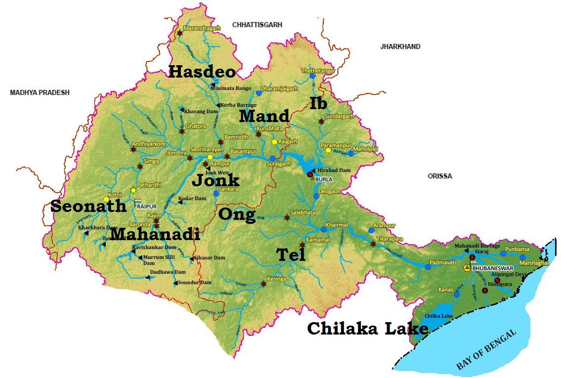
Tributaries of Mahanadi River
- Its upper course lies in the saucer-shaped basin called the ‘Chhattisgarh Plain’.
- This basin is surrounded by hills on the north, west and south as a result of which a large number of tributaries join the main river from these sides.
- Left bank Tributaries: The Seonath, the Hasdeo, the Mand and the Ib.
- Right bank Tributaries: The Ong, the Tel and the Jonk.
Projects on Mahanadi River
- Two important projects completed during pre-plan period in the basin are the Mahanadi main canaland Tandula reservoir in Chhattisgarh.
- During the plan period, the Hirakud dam, Mahanadi delta project, Hasdeo Bango, Mahanadi Reservoir Project were completed.
Industry in Mahanadi River Basin
- Three important urban centes in the basin are Raipur, Durg and Cuttack.
- Mahanadi basin, because of its rich mineral resource and adequate power resource, has a favorable industrial climate.
- The Important industries presently existing in the basin are the Iron and Steel plant at Bhilai, aluminium factories at Hirakud and Korba, paper mill near Cuttack and cement factory at Sundargarh.
- Other industries based primarily on agricultural produce are sugar and textile mills.
- Mining of coal, iron and manganese are other industrial activities.
Floods in Mahanadi River Basin
- The basin is subject to severe flooding occasionally in the delta area due to inadequate carrying capacity of the channels.
- The multi-purpose Hirakud dam provides some amount of flood relief by storing part of flood water.
- However, the problem still persists and a lasting solution need to be evolved.
Godavari River
- The Godavari is the largest river system of the Peninsular India and is revered as Dakshina Ganga.
- The Godavari basin extends over states of Maharashtra, Andhra Pradesh, Chhattisgarh and Odisha in addition to smaller parts in Madhya Pradesh, Karnataka and Union territory of Puducherry (Yanam) having a total area of ~ 3 lakh Sq.km.
- The basin is bounded by Satmala hills, the Ajanta range and the Mahadeo hills on the north, by the Eastern Ghats on the south and the east and by the Western Ghats on the west.
- The Godavari River rises from Trimbakeshwar in the Nashik district of Maharashtra about 80 km from the Arabian Sea at an elevation of 1,067 m.
- The total length of Godavari from its origin to outfall into the Bay of Bengal is 1,465 km.
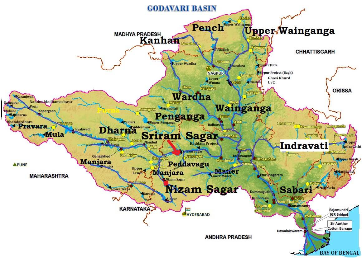
Tributaries of Godavari River
- The left bank tributaries are more in number and larger in size than the right bank tributaries.
- The Manjra (724 km) is the only important right bank tributary. It joins the Godavari after passing through the Nizam Sagar.
- Left Bank Tributaries: Dharna, Penganga, Wainganga, Wardha, Pranahita [conveying the combined waters of Penganga, the Wardha and Wainganga], Pench, Kanhan, Sabari, Indravati etc.
- Right Bank Tributaries: Pravara, Mula, Manjra, Peddavagu, Maner etc.
- Below Rajahmundry, the river divides itself into two main streams, the Gautami Godavari on the east and the Vashishta Godavari on the west and forms a large delta before it pours into the Bay of Bengal.
- The delta of the Godavari is of lobate type with a round bulge and many distributaries.
Mineral Resources in Godavari Basin
- The upper reaches of the Godavari drainage basin are occupied by the Deccan Traps containing minerals like magnetite, epidote, biotite, zircon, chlorite etc (metallic minerals)..
- The middle part of the basin is principally composed of phyllites, quartzites, amphiboles and granites (rocks).
- The downstream part of the middle basin is occupied mainly by sediments and rocks of the Gondwana group.
- The Gondwanas are principally detritals (waste or debris, in particular organic matter produced by decomposition or loose matter produced by erosion) with some thick coal seams. [Singareni Coal Seam]
- The Eastern Ghats dominate the lower part of the drainage basin and are formed mainly from the Khondalites.
Projects on Godavari River
- Important projects completed duing the plan period are Srirama Sagar, Godavari barrage, Upper Penganga, Jaikwadi, Upper Wainganga, Upper Indravati, Upper Wardha.
- Among the on-going projects, the prominent ones are Prnahita-Chevala and Polavaram.
Industry in Godavari Basin
- The major urban Centers in the basin are Nagpur, Aurangabad, Nashik, Rajhmundry.
- Nashik and Aurangabad have large number of industries especially automobile.
- Other than this, the industries in the basin are mostly based on agricultural produce such as rice milling, cotton spinning and weaving, sugar and oil extraction.
- Cement and some small engineering industries also exist in the basin.
Floods and Droughts in Godavari Basin
- Godavari basin faces flooding problem in its lower reaches.
- The coastal areas are cyclone-prone.
- The delta areas face drainage congestion due to flat topography.
- A large portion of Maharashtra falling (Marathwada) in the basin is drought prone.
Krishna River
- The Krishna is the second largest east flowing river of the Peninsula.
- The Krishna Basin extends over Andhra Pradesh, Maharashtra and Karnataka having a total area of ~2.6 lakh Sq.km.
- It is bounded by Balaghat range on the north, by the Eastern Ghats on the south and the east and by the Western Ghats on the west.
- The Krishna River rises from the Western Ghats near Jor village of Satara district of Maharashtra at an altitude of 1,337 m just north of Mahabaleshwar.
- The total length of river from origin to its outfall into the Bay of Bengal is 1,400 km.
- The major part of basin is covered with agricultural land accounting to 75.86% of the total area.
- The Krishna forms a large delta with a shoreline of about 120 km. The Krishna delta appears to merge with that formed by the Godavari and extends about 35 km into the sea.
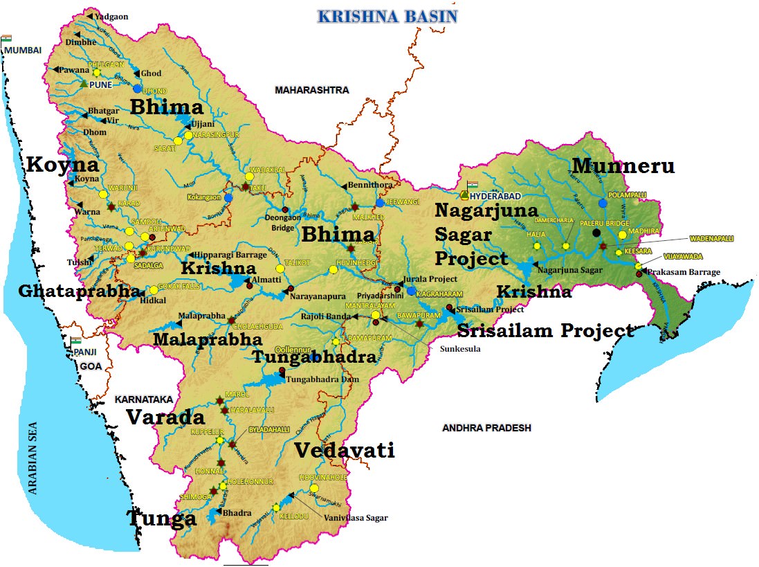
Tributaries of Krishna River
- Right bank: the Ghatprabha, the Malprabha and the Tungabhadra.
- Left Bank: the Bhima, the Musi and the Munneru.
- The Koyna is a small tributary but is known for Koyna Dam. This dam was perhaps the main cause of the devastating earthquake (6.4 on richter scale) in 1967 that killed 150 people.
- The Bhima originates from the Matheron Hills and joins the Krishna near Raichur after for a distance of 861 km.
- The Tungabhadra is formed by the unification of the Tunga and the Bhadra originating from Gangamula in the Central Sahyadri. Its total length is 531 km.
- At Wazirabad, it receives its last important tributary, the Musi, on whose banks the city of Hyderabad is located.
Projects on Krishna River
- Important ones are the Tungabhadra, Ghataprabha, Nagarjunasagar, Malaprabha, Bhima, Bhadra and Telugu Ganga.
- The major Hydro Power stations in the basin are Koyna, Tungabhadara, Sri Sailam, Nagarjuna Sagar, Almatti, Naryanpur, Bhadra.
- Tunagabhadra is a major inter-States project in the basin. In order to operate the project and to regulate the flows among the beneficiary States of Karnataka and Andhara Pradesh.
Resources in Krishna Basin
- The basin has rich mineral deposits and there is good potential for industrial development.
- Iron and steel, cement, sugar cane vegetable oil extraction and rice milling are important industrial activities at present in the basin.
- Recently oil has been struck in this basin which is bound to have an effect on the future industrial scenario of this basin.
Industry in Krishna Basin
- The major Urban Centers in the Basin are Pune, Hyderabad.
- Hyderabad is the state capital of Telangana and is now a major IT hub.
- Pune in Maharashtra has number of automobile and IT industry and is major education centre.
Drought and Floods in Krishna Basin
- Some parts of the basin, especially the Rayalaseema area of Andhra Pradesh, Bellary, Raichur, Dharwar, Chitradurga, Belgaum and Bijapur districts of Karnataka and Pune, Sholapur, Osmanabad and Ahmedanagar districts of Maharashtra are drought-prone.
- The delta area of the basin is subject to flooding. It has been observed that the river bed in delta area is continuously raised due to silt deposition resulting in reduction in carrying capacity of the channel.
- The coastal cyclonic rainfall of high intensity and short duration makes the flood problem worse.


Comments
Post a Comment