(Unit 2-Topic 1) Himalayan & The Great Northern Plains of India
Indian Geography (Unit 2-Topic 1)
Himalayan Mountains
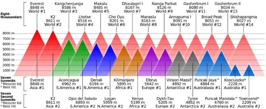
The Himalayan mountain system is the world’s highest, and home to the world’s highest peaks including Mount Everest and K2. This system also includes Karakoram, Hindu Kush and other ranges extending out from the Pamir knot. There are over 100 mountains in Himalaya system whose height exceeds 7,200m. After Himalayan peaks, it is Aconcagua, in the Andes, at 6,962 metres, known to be the highest peak outside Asia.
Extent of Himalayas
Himalaya system gives rise to some of world’s major river systems. The combined drainage basin is home to slightly less than half of world’s population. The highest peak Everest is located in Nepal. Another peak K2 is on the border of Pakistan and China. Kanchenjunga is located on the border of Nepal and India. Nanda Devi is the highest peak within India.
The main Himalayan ranges run from Indus river valley in the west to the Brahmaputra river valley in east forming a 2,400 km long arc. The width of this arc is around 400 kilometer in Western Kashmir while 150 kilometers in Arunachal Pradesh-Tibet region.
Himalayan Orogeny
Geologically, the origin of the Himalayas is the impact of the Indian tectonic plate travelling northward at 15 cm per year to impact the Eurasian continent, about 40-50 million years ago. The formation of the Himalayan arc resulted since the lighter rock of the seabeds of that time was easily uplifted into mountains. The evidence for this is that the summit of Mount Everest is made of marine limestone. Due to recent origin on geological time scale, Himalayan mountains are called Young Fold Mountains. These young fold mountains consist of a series of parallel ranges with deep valleys between them and have variety of rock structures, deep gorges and high pyramidal peaks. In High Himalayas the rivers have steep gradients, which result from the differential uplift of the High Himalayas. It has been suggested that a long and narrow arc of High Himalayas has been uplifted during quaternary.
Important Mountain passes in Himalayas
The rugged terrain makes few routes through the mountains possible. Some of these routes include:
Banihal is an important pass connecting the hill areas of Jammu to the Kashmir Valley. The Jawahar Tunnel (named after Pandit Jawaharlal Nehru), inaugurated in December 1956, was constructed for round-the-year surface transport
Zoji La lies between the valley of Kashmir and the Kargil district, and is the only Western entrance to the highlands of Ladakh.
Rohtang Pass in Himachal Pradesh, India.
Mohan Pass is the principal pass in the Shiwalik Hills, the southernmost and geologically youngest foothills running parallel to the main Himalayas in Sikkim.
Kora La at 4,594 meters elevation on the Nepal-Tibet border at the upper end of Mustang. The Kali Gandaki Gorge transects the main Himalaya and Transhimalayan ranges. Kora La is the lowest pass through both ranges between K2 and Everest, but some 300 metres higher than Nathula and Jelepla passes further east between Sikkim and Tibet.
Aghill Pass: Situated to the north of K2 in the Karakoram at an elevation of 5000 meters, joins Ladakh with the Xinjiang Province of China.
Bara-Lacha: Bara-lacha la also known as Bara-lacha Pass is located in the Zanskar range connecting Lahaul district in Himachal Pradesh to Ladakh in Jammu and Kashmir, situated along the Leh-Manali highway.
Bomdi-La: It connects Arunachal Pradesh with Lhasa, the capital of Tibet.
Chang-La: The Changla Pass or Chang La Pass (el. 5,360 m is located in Ladakh, India. It is the third highest motorable road in the world.
Debsa Pass: Debsa Pass is a 5,360-metre (17,590 ft) high mountain pass in the Himalaya mountains between the Kullu and Spiti Districts of Himachal Pradesh.
Dihang-Debang: Situated in the state of Arunachal Pradesh at an elevation of about 4000 feet this pass connects Arunachal Pradesh with Mandalay (Myanmar). The Dihang-Debang Biosphere reserve is located around this area.
Himalayan Ranges: Shiwaliks, Middle Himalayas, Greater Himalayas, Trans-Himalayas & Purvanchal
Major Physical Divisions of India
- The Himalayas (young fold mountains),
- Indo-Gangetic Plain (monotonous topography – featureless topography),
- The Peninsular Plateau (one of the most stable landmasses; one of the oldest plateaus of the world),
- Coastal Plains (Sediments due to fluvial action).
- The Indian Islands [Coral Islands == coral reef built up on atolls – Lakshadweep. Tectonic == Andaman and Nicobar Islands – Interaction between Indian Plate and Eurasian plate] and
Peninsular Plateau
- Includes the entire south India, central India, Aravalis, Rajmahal hills, Meghalaya plateau, Kuchchh-Kathiawar region (Gujarat) etc..
- It is the oldest and the most stable landmass of India.
Himalayas
- Includes the Himalayas, Purvanchal and their extensions Arakan Yoma (Myanmar) and Andaman and Nicobar Islands (but we will consider these as islands only).
- It is the youngest and highly unstable landmass of India. [Continent – Continent Convergence]
- Tectonic movements are very common.
Indo-Gangetic Plain
- Between Peninsular and Himalayan region.
- Most youthful, monotonous [lack of change or variety] region prone to tectonic forces.
Coastal Plains
- Eastern Coastal Plains and Western Coastal Plains.
- Formed due to consolidation of sediments brought by rivers (fluvial deposits).
- Highly stable just like peninsular plateau.
Indian Islands
- Two major groups – Lakshadweep and, Andaman and Nicobar islands.
- Lakshadweep [Hotspot] are group of atolls occupied by coral reefs. No significant volcanism or tectonic activity in recent past. Highly vulnerable to sea-level rise.
- Andaman and Nicobar islands – Continuation of Arakan Yoma. Has active volcanoes and is tectonically active.
Type of Topography | Extent in % |
| Mountainous (more than 2135 m above sea level) | 10.7 |
| Hilly area (305 – 2135 m above sea level) | 18.6 |
| Plateau (305 – 915 m above sea level) | 27.7 |
| Plains | 43 |
Division of the Himalayas
Formation of Himalayas explained in Continent – Continent Convergence.
- Shiwaliks or outer Himalayas
- Lesser or Middle Himalayas
- The Greater Himalayas
- The Trans-Himalayas – Tibetan Himalayas.
- The Eastern Hills – Purvanchal: A chain of hills in North-East India.
Himalayan Ranges
- Series of several parallel or converging ranges.
- The ranges are separated by deep valleys creating a highly dissected topography [(of a plateau or upland) divided by a number of deep valleys].
- The southern slopes have steep gradients and northern slopes have comparatively gentler slopes. [Scaling Mount Everest is less hectic from the northern side. But China puts restrictions so climbers take the steeper southern slopes from Nepal]
- Most of the Himalayan ranges fall in India, Nepal and Bhutan. The northern slopes are partly situated in Tibet (trans-Himalayas) while the western extremity lies in Pakistan, Afghanistan and Central Asia.
- Himalayas between Tibet and Ganga Plain is a succession of three parallel ranges.
Shiwalik Range
- Also known as Outer Himalayas.
- Located in between the Great Plains and Lesser Himalayas.
- The altitude varies from 600 to 1500 metres.
- Runs for a distance of 2,400 km from the Potwar Plateau to the Brahmaputra valley.
- The southern slopes are steep while the northern slopes are gentle.
- The width of the Shiwaliks varies from 50 km in Himachal Pradesh to less than 15 km in Arunachal Pradesh.
- They are almost unbroken chain of low hills except for a gap of 80-90 km which is occupied by the valley of the Tista River and Raidak River.
- Shiwalik range from North-East India up to Nepal are covered with thick forests but the forest cover decreases towards west from Nepal (The quantum of rainfall decreases from east to west in Shiwaliks and Ganga Plains).
- The southern slopes of Shiwalik range in Punjab and Himachal Pradesh are almost devoid of forest cover. These slopes are highly dissected by seasonal streams called Chos.
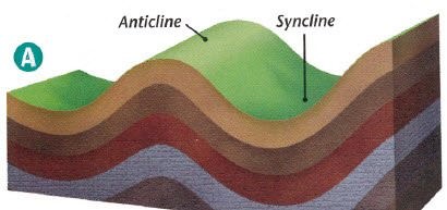
- Valleys are part of synclines and hills are part of anticlines or antisynclines.
Formation (Formation of Himalayas already explained)
- Shiwaliks were formed last of all the ranges (2-20 million years ago).
- The Shiwaliks are consolidated sands, gravels and conglomerate deposits [Alluvial fans] which were brought by the rivers flowing from the higher ranges.
- These deposits were folded and hardened due to compression offered by the northward movement of Indian plate.
The Shiwaliks are known by different names in different areas
Region | Name of Shiwaliks |
| Jammu Region | Jammu Hills |
| Dafla, Miri, Abor and Mishmi Hills | Arunachal Pradesh |
| The Dhang Range, Dundwa Range | Uttarakhand |
| Churia Ghat Hills | Nepal |
Explain the formation of Duns (Duras)
- Shiwalik Hills were formed by the accumulation of conglomerates (sand, stone, silt, gravel, debris etc.).
- These conglomerates, in the initial stages of deposition, obstructed the courses of the rivers draining from the higher reaches of the Himalayas and formed temporary lakes.
- With passage of time, these temporary lakes accumulated more and more conglomerates. The conglomerates were well settled at the bottom of the lakes.
- When the rivers were able to cut their courses through the lakes filled with conglomerate deposits, the lakes were drained away leaving behind plains called ‘duns’ or ‘doons’ in the west and ‘duars’ in the east.
- Dehra Dun in Uttarakhand is the best example [75 km long and 15-20 km wide]
- Kotah, Patli Kothri, Chumbi, Kyarda, Chaukhamba, Udhampur and Kotli are other important duns.
Middle or the Lesser Himalaya
- In between the Shiwaliks in the south and the Greater Himalayas in the north.
- Runs almost parallel to both the ranges.
- It is also called the Himachal or Lower Himalaya.
- Lower Himalayan ranges are 60-80 km wide and about 2400 km in length.
- Elevations vary from 3,500 to 4,500 m above sea level.
- Many peaks are more than 5,050 m above sea level and are snow covered throughout the year.
- Lower Himalayas have steep, bare southern slopes [steep slopes prevents soil formation] and more gentle, forest covered northern slopes.
- In Uttarakhand, the Middle Himalayas are marked by the Mussoorie and the Nag Tibba ranges.
- The Mahabharat Lekh, in southern Nepal is a continuation of the Mussoorie Range
- East of the Kosi River, the Sapt Kosi, Sikkim, Bhutan, Miri, Abor and Mishmi hills represent the lower Himalayas.
- The Middle Himalayan ranges are more friendly to human contact.
Majority of the Himalayan hill resorts like Shimla, Mussoorie, Ranikhet, Nainital, Almora and Darjeeling, etc. are located here.
Important ranges of Lesser Himalayas | Region |
| The Pir Panjal Range | Jammu and Kashmir (They are to the south of Kashmir Valley) |
| The Dhaola Dhar Range | Himachal Pradesh |
| The Mussoorie Range and The Nag Tiba Range | Uttarakhand |
| Mahabharat Lekh | Nepal |
The Pir Panjal range
- The Pir Panjal range in Kashmir is the longest and the most important range.
- It extends from the Jhelum river to the upper Beas river for over 300 km.
- It rises to 5,000 metres and contains mostly volcanic rocks.
Passes in Pir Panjal
- Pir Panjal Pass (3,480 m), the Bidil (4,270 m), Golabghar Pass (3,812 m) and Banihal Pass (2,835 m).
- The Banihal Pass is used by the Jammu-Srinagar highway and Jammu-Baramula railway.
- The Kishanganga, the Jhelum and the Chenab cut through the range.
- Southeast of the Ravi, the Pir Panjal continues as Dhaola Dhar range, passing through Dalhousie, Dharmshala, and Shimla.
Important Valleys
- Between the Pir Panjal and the Zaskar Range of the main Himalayas, lies the valley of Kashmir. (average elevation is 1,585 m above mean sea level)
- The synclinal basin of the valley is floored with alluvial, lacustrine [lake deposits], fluvial [river action] and glacial deposits. {Fluvial Landforms, Glacial Landforms}
- Jehlum River meanders through these deposits and cuts a deep gorge in Pir Panjal through which it drains. (Kashmir is like a basin with very few outlets)
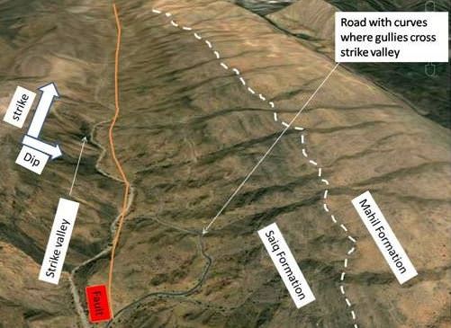
- In Himachal Pradesh there is Kangra Valley. It is a strike valley and extends from the foot of the Dhaola Dhar Range to the south of Beas.
- On the other hand, the Kulu Valley in the upper course of the Ravi is transverse valley.
Strike valley vs. Transverse valley
 |
The Great Himalaya
- Also known as Inner Himalaya, Central Himalaya or Himadri.
- Average elevation of 6,100 m above sea level and an average width of about 25 km.
- It is mainly formed of the central crystallines (granites and gneisses) overlain by metamorphosed sediments [limestone]. {Rock System}
- The folds in this range are asymmetrical with steep south slope and gentle north slope giving ‘hog back (a long, steep hill or mountain ridge)’ topography.
- This mountain arc convexes to the south just like the other two.
- Terminates abruptly at the syntaxial bends. One in the Nanga Parbat in north-west and the other in the Namcha Barwa in the north-east.
- This mountain range boasts of the tallest peaks of the world, most of which remain under perpetual snow.
Regional name of Mount Everest | Region |
| Sagarmatha (The Goddess of the Sky) | Nepal |
| Chomlungma (Mother of the World) | China (Tibet) |
- Mount Everest was first located by George Everest, the then Surveyor General of India in 1841 and in 1852 it was established as the highest peak of the world by the Great Trigonometrical Survey of India.
Passes in the Greater Himalayas
- The passes because they are generally higher than 4,570 m above sea level and are snowbound for most of the year.
State | Passes of Greater Himalayas |
| Jammu and Kashmir |
|
| Himachal Pradesh |
|
| Uttarakhand |
|
| Sikkim |
|
The Trans Himalayas
- The Himalayan ranges immediately north of the Great Himalayan range.
- Also called the Tibetan Himalaya because most of it lies in Tibet.
- The Zaskar, the Ladakh, the Kailas and the Karakoram are the main ranges.
- It stretches for a distance of about 1,000 km in east-west direction.
- Average elevation is 3000 m above mean sea level.
- The average width of this region is 40 km at the extremities and about 225 km in the central part.
- The Nanga Parbat (8126 m) is an important range which is in The Zaskar Range.
- North of the Zaskar Range and running parallel to it is the Ladakh Range. Only a few peaks of this range attain heights of over 6000 metres.
- The Kailas Range (Gangdise in Chinese) in western Tibet is an offshoot of the Ladakh Range. The highest peak is Mount Kailas (6714 m). River Indus originates from the northern slopes of the Kailas range.
- The northern most range of the Trans-Himalayan Ranges in India is the Great Karakoram Rangealso known as the Krishnagiri range.
- Karakoram Range extends eastwards from the Pamir for about 800 km. It is a range with lofty peaks [elevation 5,500 m and above]. It is the abode of some of the greatest glaciers of the world outside the polar regions.
- Some of the peaks are more than 8,000 metre above sea level. K2 (8,611 m)[Godwin Austen or Qogir] is the second highest peak in the world and the highest peak in the Indian Union.
- The Ladakh Plateau lies to the north-east of the Karakoram Range. It has been dissected into a number of plains and mountains [Soda Plains, Aksai Chin, Lingzi Tang, Depsang Plains and Chang Chenmo]
Purvanchal or Eastern Hills
- Eastern Hills or The Purvanchal are the southward extension of Himalayas running along the north-eastern edge of India.
- At the Dihang gorge, the Himalayas take a sudden southward bend and form a series of comparatively low hills which are collectively called as the Purvanchal.
- Purvanchal hills are convex to the west.
- They run along the India-Myanmar Border extending from Arunachal Pradesh in the north to Mizoram in the south.
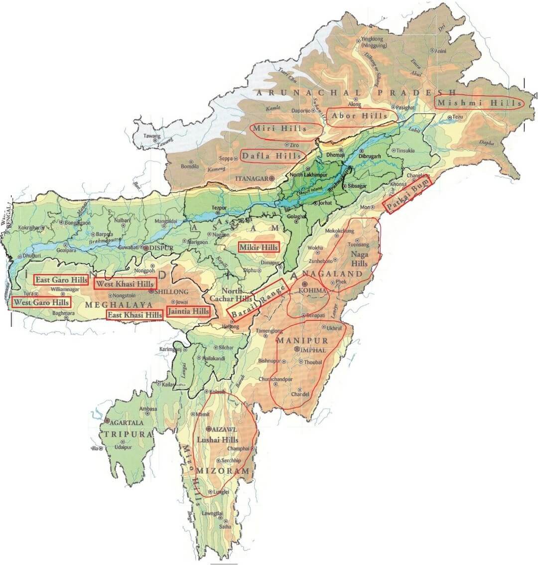
- Patkai Bum hills are made up of strong sandstone; elevation varying from 2,000 m to 3,000 m; merges into Naga Hills where Saramati (3,826 m) is the highest peak.
- Patkai Bum and Naga Hills form the watershed between India and Myanmar.
- South of Naga Hills are the Manipur hills which are generally less than 2,500 metres in elevation.
- The Barail range separates Naga Hills from Manipur Hills.
- Further south the Barail Range swings to west into Jaintia, Khasi and Garo hills which are an eastward continuation of the Indian peninsular block. They are separated from the main block by Ganga and Brahmaputra rivers.
- South of the Manipur Hills are the Mizo Hills (previously known as the Lushai hills) which have an elevation of less than 1,500 metres. The highest point is the Blue Mountain (2,157 m) in the south.
Syntaxial Bends of the Himalayas
- Himalayas extend in the east-west direction from the Indus gorge in the west to the Brahmaputra gorge in the east.
- Himalayan ranges take sharp southward bends at these gorges. These bends are called syntaxial bends of the Himalayas.
- The western syntaxial bend occurs near the Nanga Parbat where the Indus river has cut a deep gorge.
- The eastern syntaxial bend occurs near the Namche Barwa.
________________________________________________________________________
The Great Northern Plains of India

The Great plain of Northern India lies on the south of the Himalayas. It is, in fact, bounded by the Himalayas on the north and the Deccan plateau on the south. This plain stretches for about 2,400 km from east to west and 200 to 400 km from north to south. It covers an area of about 5,80,000 sq km.
Origin
The Great plain of Northern India was formed by the sediments brought down by the Indus-Ganga-Brahmaputra and their tributaries and it is popularly known as the Indo-Ganga-Brahmaputra plain. Geologists suggest that there was a shallow trough or geosyncline in between the Himalayas and the Deccan plateau during the latter geological period of the formation of the Himalayas.
After the upliftment of the Himalayas, sediments and debris brought down by the rivers, began to accumulate there to form the vast alluvial plain of northern India.
Relief
This extensive plain is level and monotonous; it is characterized by some local diversities. Hence, it may be classified into three divisions:
- The Punjab plain drained by the Indus,
- The Ganga plain drained by the Ganga and
- The Brahmaputra valley drained by the Brahmaputra.
1. The Punjab Plain
The Western part of the Northern plain is known as the Punjab plain. The plain is drained by the Indus and its tributaries, such as, the Sutlej, Beas and Ravi. Only a part of the Indus basin lies in India. The plain slopes gently down towards the south-west; hence the rivers follow the slope of the land. The plain is mostly made of silts. The soil is porous. The plain that is formed by the deposition of new alluvium near the river banks is called Bet.
Large boulder, gravel, sand and clay cover the foot-hill regions of the Punjab plain and they are known as ‘Bhabar’ plain or bhabar soil. This soil cannot hold water. The new alluvium deposited near the river banks of these rivers forms a plain called Bet.
2. The Ganga Plain
The major portion of the Great Indian Plain consists of tile Ganga basin. It extends from the eastern margin of the Punjab in the west to Bangladesh border in the east. This is an extensive plain encompassing states such as Uttar Pradesh, Bihar and West Bengal.
It is drained by the rivers such as Yamuna, Ganga, Ghaghara, Gandak, Kosi and Tista from the Himalayas in the north and Chambal, Betwa, Son and Damodar from the plateau in the south. The entire region slopes towards south and south-east.
It is monotonous alluvial plain with little undulation. The lower reaches of the Ganga plain is slightly above the sea-level; however, the upper portion rises up to 200 meters. The Ganga forms a great delta on its mouth. Its deltaic part presents the three distinctive features of delta formation, such as, the moribund delta, mature delta and active delta.
The Ganga plain is the most populous part of India. People of this plain are mainly engaged in agriculture. Trade, industry and commerce are also prosperous.
Divisions: This plain may be divided into three regions:
- Upper Ganga plain: It stretches from the Yamuna river in the west to Allahabad city in the east,
- Middle Ganga plain: It stretches from Allahabad (Uttar Pradesh) in the west to Rajmahal hill in the east, and
- Lower Ganga plain: It stretches from Rajmahal hill to the Bay of Bengal.
3. The Brahmaputra Valley
It lies in the north-eastern part of the country and is hemmed between the Arunachal Himalayas on the north and the Meghalaya Plateau on the south.
The valley presents a flat plain. It is formed by the debris brought down by river Brahmaputra and its innumerable tributaries. The plain seldom rises above 100 meters above the sea-level and slopes gently towards the west. Ranges of hills are found standing on both sides of the river.
Innumerable Sandbars and islets are found on the Brahmaputra and the river flows out in different channels avoiding obstacles of sandbar. Majuli Island is by far the largest sandbar ever formed on any other river bed in the world. The green Brahmaputra valley is noted for tea plantation.


Comments
Post a Comment