(Unit 2-Topic 2) Peninsular Plateau, Geological History, Central Highlands, Deccan Plateau
Indian Geography (Unit 2-Topic 2)
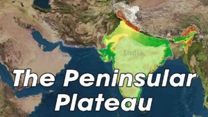
Peninsular Plateau of India
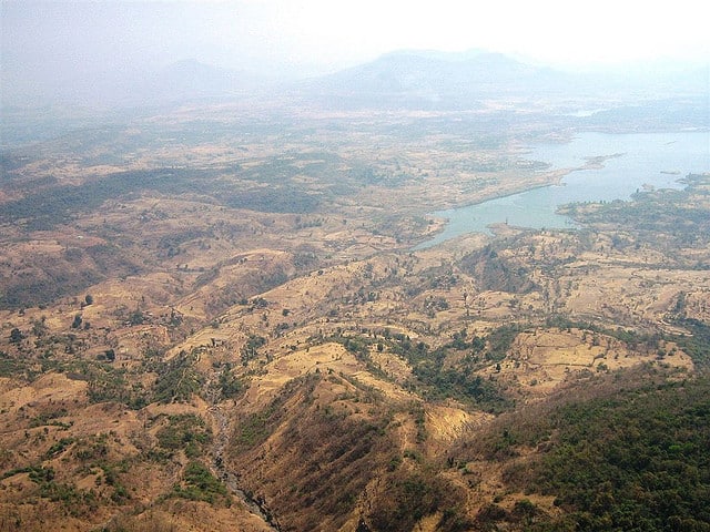
Peninsular Plateau is of the triangular shaped. the extension of this is from the south of Indo-Ganga Plain to the Kanyakumari.
Peninsular PlateauPeninsular Plateau is one of the oldest surfaces of the earth it represents a segregated part of the old Gondwanaland.
Physical features:
The Satpura, the Mahadeo and the Kaimur range in the south and the Aravalli range in the west divide the Peninsular Plateau into two parts:
1.The Central Indian Plateau in the north and
2.The Deccan Plateau in the south of it.
Central Indian Plateau:
The central Indian plateau lies in the Aravali mountain which goes through the Delhi and the Ahmadabad.
In the southern part of this, the Abu hill contains the Guru Shikhar which is 1722 m in height. The two noted range of this plateau is Vidhya and sathpuda.
In this the rift valleys The Tapti and the Narmada flows and the Satpuras which is about 600-900 m in height which presents a block mountain formed in between these two flows. The highest peak of this plateau is Dhupgarh which is 1350 m in height.
Besides this in the East of the Satpuras runs the Mahadeo and the Maikala Range in the cool and almighty way of nature.
The range of Vindhya is extending from the western boundary of Madhya Pradesh runs at first eastward and then northeastward. Its highest peak is the Manipur which is 881 m high
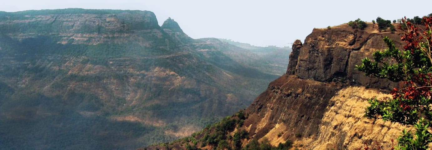
The Deccan Plateau
The highest peak of Eastern Ghats is Mahendragiri which is 1680 m in height
the Western Ghats The Eastern Ghats and meet at the Nilgiri Hills in South Karnataka.
Doddabetta which is 2637 m in height that is the highest peak of the Nilgiri mountains.
In the South of the Nilgiri lies the Palghat Gap, which facilitates between Kerala and the interior of India.
The Anaimalai Range extends in the south of the Palghat Gap. Its highest peak Anaimudi which is 2695 m in height is also the highest in South India. The Anaimalai throws off two branches viz. the Palni Range in the north-east and the Cardamom or the Elumalai Range in the south.
The Deccan Plateau is little fired by the hills and mountains, that are Satpura, Mahadeo, Kaimur ranges on the north, the Western Ghat on the west and the Eastern Ghat on the east. It forms a large portion of South India.
from the West Coastal Plain and descends towards eastward the Sahyadri or the western ghat rises slowly. near Nasik Thalghat and near Pune Bhorghat are two mountain gaps which connect Mumbai and the West Coast to the rest of India by rail and road.
The eastern ghat of the Shayhyadri get wasted by the western ghat which is situated in the valleys of the western ghat is as follows which are going through the valleys. Mahendragiri is the highest peak of the Eastern Ghats which is 1680 m in height.
In south Karnataka, the eastern ghat and the western ghat both meet at the Nilgiri hills that are awesome views of the Nilgiri hills. The highest peak of the Nilgiri mountains. Is Doddabetta which is 2637 m in height. for the communication between Kerala and the interior of India, there is the south of the Nilgiri lies in the Palghat Gap, which facilities the beautiful lies and connection between them.
The Anaimalai Range is spread through the south of the Palghat Gap. the highest peak of the animal is the Anaimudi which is in 2695 m of the height. It is also the highest peak in South India. The Anaimalai is created from the two branches which are the Palni Range which is in the north-east and the Cardamom or the Elumalai Range in the south.
Physical description of the Plateau
Maharashtra has the greater part which the I type of the lava that is the lava plateau which is also called as the volcanic plateau that is called Deccan Trap. The plateau resulted from a horizontal disposition of the lava of the volcanic plateau is still in the liquid state.
The difference of the plateau is done by rivers which have risen on the top of the hills or steps formed by cases the erosion on soft ash and hard lava beds. Besides this Maharashtra, Deccan trap is spread through over Madhya Pradesh and Gujarat.
The large portion of this Deccan Plateau consists the volcanic rocks which are also called as the basalt. In that, the Several layers of volcanic corrosion and the eruptions that occurred for thousands of years that resulted in the formation of this Deccan Trap.
In the East of Maharashtra lies the form of the Upper Mahanadi Basin or is called the Chhattisgarh Plain, to the north of which is the get bisected in the Baghelkhand Plateau and is spread to the south the mountainous Dandakaranya.
There is the Plain extends the rectangular Chota Nagpur Plateau In the north-eastern part of the Deccan and to the west of lower Gangetic. The major part of this central part of the plateau is covered and spread by the extensive Ranchi Plateau which is an average height of about 700 m in height.
At the edge of the Ranchi, Plateau is considered by the several waterfalls of which are Hundru, Jonha, Dasham and Hirni are especially very attractive and that can be very piece full to everyone. South of this Ranchi Plateau is the covered by the high and rugged Garhjat Hills which get included by their hills. The lava hills of Rajmahal spread through the and end at the lake of the Chota Nagpur Plateau on the north-east.
The Lava of Maharashtra Plateau is spread through the end of the southwest through Karnataka Plateau and in the southeast till the Telangana Plateau.
this was the beautiful description of the Peninsular Plateau. Theis is one of the gods places on the earth from where the one can feel the touch of the god through the attractive and the beauty of nature.
The peninsular plateau is the one plateau which is spread through the Indi which the sign if the natural activity of the gods. Some people used to go through all the plateau over the India.
______________________________________________________________________
Geological History of India

India is mostly located on the Indian Plate, which is generally called the northern portion of the Indo-Australian Plate. Indian subcontinent, Australia, New Guinea, and Tasmania, New Zealand etc. have a common geological history by virtue of being an integral part of the Mesozoic Gondwana super-continent until 160 million years ago.
The earth is 4700 million years old and the earliest supercontinent Vaalbara started forming around 3600 million years ago. It took nearly 400 million years to get completed and was ready by 3100 million years ago. Then, around 2500 years ago, Vaalbara started breaking. The result of this breaking was that another supercontinent Kenorland formed around 2700-2500 million years ago. The breaking kept on and then Supercontinent Columbia formed around 1800-1500 million years ago.
Around 750 million years ago, a new supercontinent was formed that was called Rodinia. In the late Paleozoic period (542 – 250 million years ago) super continent Pangaea was formed that existed during the Paleozoic and Mesozoic eras. Pangaea started beginning to break up approximately 200 million years ago, before the component continents were separated into their current configuration. It first broke into Northern Laurasia (Angaraland) and Southern Gondwanaland.
Later, the Laurasia and Gondwana drifted apart. Gondwana included Antarctica, South America, Africa, Madagascar, Australia-New Guinea, and New Zealand, as well as Arabia and the Indian subcontinent, which have now moved entirely into the Northern Hemisphere.
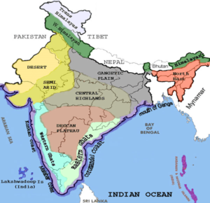
Thus, from geological history two main structural divisions of India are:
Himalayan Mountain Chain, which is a part of Laurasia or Angaraland
southern pan called Gondwanaland of which Peninsular India formed one of the blocks.
The intervening space between the two giant continental blocks was filled with water. It was a shallow sea called Tethy’s Sea. During the subsequent geological periods, the Indian Peninsular block began drifting northward leaving a huge gap filled with water which truly came to be called the Indian Ocean. As the peninsular block continued its drift northward, the Indian Ocean continued to advance and filled up the depressions on either side of the landmass when it compressed the Tethy’s Sea. Thus, the Arabian Sea and Bay of Bengal were formed. What was once the Tethy’s Sea has become the Mediterranean Sea. Other remnants are the Black, Caspian, and Aral Seas (via a former inland branch known as the Paratethys).
The similarity in the geological formation produced more or less similar type of mineral wealth in both India and Australia. Despite the variance in the biotic life between India and Australia, there are certain endemic plant and animal species, pointing to the super continent connection.
Please note that Strait of Lombok is part of the biogeographical boundary between the fauna of Indomalaya ecozone and the distinctly different fauna of Australasia. The boundary is known as the Wallace Line, for Alfred Russel Wallace, who first remarked upon the striking difference between animals of Indo-Malaysia from those of Australasia and how abrupt the boundary was between the two biomes.
________________________________________________________________________


______________________________________________________________________
Geological History of India

India is mostly located on the Indian Plate, which is generally called the northern portion of the Indo-Australian Plate. Indian subcontinent, Australia, New Guinea, and Tasmania, New Zealand etc. have a common geological history by virtue of being an integral part of the Mesozoic Gondwana super-continent until 160 million years ago.
The earth is 4700 million years old and the earliest supercontinent Vaalbara started forming around 3600 million years ago. It took nearly 400 million years to get completed and was ready by 3100 million years ago. Then, around 2500 years ago, Vaalbara started breaking. The result of this breaking was that another supercontinent Kenorland formed around 2700-2500 million years ago. The breaking kept on and then Supercontinent Columbia formed around 1800-1500 million years ago.
Around 750 million years ago, a new supercontinent was formed that was called Rodinia. In the late Paleozoic period (542 – 250 million years ago) super continent Pangaea was formed that existed during the Paleozoic and Mesozoic eras. Pangaea started beginning to break up approximately 200 million years ago, before the component continents were separated into their current configuration. It first broke into Northern Laurasia (Angaraland) and Southern Gondwanaland.
Later, the Laurasia and Gondwana drifted apart. Gondwana included Antarctica, South America, Africa, Madagascar, Australia-New Guinea, and New Zealand, as well as Arabia and the Indian subcontinent, which have now moved entirely into the Northern Hemisphere.
Thus, from geological history two main structural divisions of India are:
Himalayan Mountain Chain, which is a part of Laurasia or Angaraland
southern pan called Gondwanaland of which Peninsular India formed one of the blocks.
The intervening space between the two giant continental blocks was filled with water. It was a shallow sea called Tethy’s Sea. During the subsequent geological periods, the Indian Peninsular block began drifting northward leaving a huge gap filled with water which truly came to be called the Indian Ocean. As the peninsular block continued its drift northward, the Indian Ocean continued to advance and filled up the depressions on either side of the landmass when it compressed the Tethy’s Sea. Thus, the Arabian Sea and Bay of Bengal were formed. What was once the Tethy’s Sea has become the Mediterranean Sea. Other remnants are the Black, Caspian, and Aral Seas (via a former inland branch known as the Paratethys).
The similarity in the geological formation produced more or less similar type of mineral wealth in both India and Australia. Despite the variance in the biotic life between India and Australia, there are certain endemic plant and animal species, pointing to the super continent connection.
Please note that Strait of Lombok is part of the biogeographical boundary between the fauna of Indomalaya ecozone and the distinctly different fauna of Australasia. The boundary is known as the Wallace Line, for Alfred Russel Wallace, who first remarked upon the striking difference between animals of Indo-Malaysia from those of Australasia and how abrupt the boundary was between the two biomes.
________________________________________________________________________
Central Highlands in India, Indian Physiography
Central Highlands in India are made of the Malwa Plateau, Deccan Plateau and Chota Nagpur Plateau.
Central Highlands in India can be defined as a bio-geographic zone. These highlands have been formed by the disjunct ranges of the Satpura and Vindhya Hills. The Malwa Plateau in the west, the Deccan Plateau in the south (covering majority of the Indian peninsula) and the Chota Nagpur Plateau in the east are the most important regions of the Indian subcontinent and the Central Highlands in India.
Malwa Plateau
The Malwa Plateau is located in Rajasthan, Madhya Pradesh and Gujarat. The average altitude of the Malwa Plateau is about 500 meters and the landscape generally slopes towards the north. The Chambal River and its tributaries drain most of the region. The upper reaches of the Mahi River drain the western part.
Deccan Plateau
Deccan Plateau is a large triangular plateau, surrounded by the Vindhyas to the north and flanked by the Eastern and Western Ghats. It covers a total area of about 1.9 million square kilometers. It is mostly flat, with elevations ranging from 300 to 600 m (1,000 to 2,000 ft). The average elevation of the plateau is about 2,000 feet (600 m) above sea level. The surface slopes from 3,000 feet (900 m) in the west to 1,500 feet (450 m) in the east. It slopes gently from west to east and gives rise to several peninsular rivers such as the Godavari, the Krishna, the Kaveri and the Narmada, which drain into the Bay of Bengal. This region is mostly semi-arid as it lies on the lower side of both Ghats. Much of the Deccan is encompassed by thorn scrub forest scattered with small regions of deciduous broadleaf forest. Climate in the Deccan ranges from hot summers to mild winters.
Chota Nagpur Plateau
Chota Nagpur Plateau is located in eastern India and is one of the central highlands in India, covering much of the Indian state of Jharkhand and adjacent parts of Odisha, Bihar and Chhattisgarh. Its total area is approximately 65,000 square kilometers and it is made up of three smaller plateaus, namely the Ranchi, Hazaribagh, and Kodarma plateaus.
The Ranchi Plateau is the largest, with an average elevation of about 700 m (2,300 ft). Much of the plateau is forested, covered by the Chota Nagpur dry deciduous forests. The Hazaribagh Plateau is divided into two parts namely, the higher plateau and the lower plateau. The Hazaribagh town has been built on the Hazaribagh Plateau.
It has an average elevation of about 610 m (2,000 ft). The Koderma Plateau or the Hazaribagh Lower Plateau has uniform and gentle slope towards the east. The northern face of the Kodarma Plateau looks like a range of hills, but in actuality it is the edge of a plateau, which is about 240 meters from the level of the Gaya Plain. Huge reserves of metal ores and coal have been found in the Chota Nagpur Plateau.
_________________________________________________________________________________
_________________________________________________________________________________
Deccan Plateau
Important Notes on Deccan Plateau
- This Plateau makes up a triangle nested within the familiar downward-pointing triangle of the Indian sub-continent’s coastline.
- In the south, the plateau is mostly over 1,000 metres above sea level. In the north it is mostly about 500 m above sea level. The Deccan Plateau is higher in the west and slopes gently eastwards. This would imply that most Deccan plateau rivers flow from west to east. The rivers flowing through the Deccan plateau have cut deep valleys and divided the plateau into several smaller plateus such as the Maharastra Plateau, Andhra Plateau and Karnataka Plateau.
- The plateau is very big and there are many habitats: different Ecosystems with different sorts of vegetation, climate, geology and animals. The forests on the plateau are older than the Himalayan mountains.
- The Western Ghats mountain range is tall and blocks the moisture from the southwest monsoon from reaching the Deccan Plateau, this is the reason that the Deccan Plateau region receives very little rainfall.
- The Godavari River and its tributaries, including the Indravati River, drain most of the northern portion of the plateau, rising in the Western Ghats and flowing east towards the Bay of Bengal. The Tungabhadra River, Krishna River and its tributaries, including the Bhima River, which also run from west to east, drain the central portion of the plateau.
- The southernmost portion of the plateau is drained by the Kaveri River, which rises in the Western Ghats of Karnataka and bends south to break through the Nilgiri Hills at Hogenakal Falls into Tamil Nadu, then forming the Sivasamudram Falls at the island town of Shivanasamudra, the second-biggest waterfall in India and the sixteenth-largest in the world, before flowing into the Stanley Reservoir and the Mettur Dam that created the reservoir and finally emptying into the Bay of Bengal.
- The two main rivers which do not flow into the Bay Of Bengal are the Narmada and Tapti. They start in the Eastern Ghats and flow into the Arabian Sea.


Comments
Post a Comment