Phy Geo (Unit 3-Topic 1) Ocean Relief, Ocean Deposits, Ocean Currents, Ocean Tides, Ocean Salinity
Physical Geography (Topic 1-Unit 3)
Ocean Relief : Key Features and Types of Ocean Relief
Ocean is blue because water shows slightly blue color and that is because of the fact that it absorbs the Red photons of the light. Because the absorption which gives water its color is in the red end of the visible spectrum, one sees blue, the complementary color of red, when observing light that has passed through several meters of water.
Some Extreme Points in Oceans
- The deepest point in the ocean is the Mariana Trench, located in the Pacific Ocean near the Northern Mariana Islands.
- Its maximum depth has been estimated to be 10,971 meters (plus or minus 11 meters).
- British naval vessel, Challenger II surveyed the trench in 1951 and named the deepest part of the trench, the “Challenger Deep”.
- In 1960, the Trieste successfully reached the bottom of the trench, manned by a crew of two men.
The ocean relief can be divided into various parts such as Continental Shelf, Continental Slope, Continental Rise or Foot, Deep Ocean basins, Abyssal plains & Abyssal Hills, Oceanic Trenches, Seamounts and Guyots.

Continental Shelf
Continental Shelf is the submerged edge of a continent. It is a gently sloping plain that extends into the Ocean. The typical gradient is less than 1°. Taken together, total area of the continental shelves is 18% of earth’s dry land area. The width of the continental shelf varies considerably; there are many places on earth where there is virtually no shelf at all. The largest continental shelf is the Siberian Shelf in the Arctic Ocean, which stretches to 1,500 kilometers in width. The average width of continental shelves is about 80 km. The depth of the shelf also varies, but is generally limited to water shallower than 150 m. Continental shelf is made up of Granite rock overlain by the sediments. Because of the gentle slope, the continental shelf is influenced by the changes in the sea level.

Continental Slope & Continental Rise
Continental slope is relatively steep descent from the shelf break to the deep sea floor. Inclination of the typical continental slope is around 4° and usually between 2° to 5°. Shelf break is almost constant all over the globe and is around 150 meters, except the Antarctica and Greenland continental slopes. The slope plunges down at least 1 kilometer and usually 2-3 kilometers.
The Continental Rise connects the Continental slope to the deep sea or abyssal plain. Its width is around 100-1000 kilometers. Slope is gradual and around l/8th of the continental slope. The transition from continental to oceanic crust commonly occurs within the continental rise.
Deep Ocean basin & Oceanic Ridges
Deep Ocean Basin is the lowest layer in the ocean. The sea floor is like a covering of sediments over a basalt rock which may be up to 5 kilometers thick. Oceanic ridges or Mid-oceanic Ridges refer to the boundary between the diverging plates. A mid-ocean ridge (MOR) refers to an underwater mountain system that consists of various mountain ranges (chains), typically having a valley known as a rift that runs along its spine, formed by plate tectonics. The midoceanic ridge of submarine hills divides the basin in about half. Precisely in the center of the ridge, at its highest point, is a narrow trenchlike feature called the axial rift. The location and form of this rift suggest that the crust is being pulled apart along the line of the rift.

The oceanic ridges present a mountainous chain of young rocks which stretch around 65000 kilometers, i.e. 1.5 times of the earth’s circumference. Oceanic ridges are made up of basalt rocks,, are geologically active as the new magma constantly emerging onto the ocean floor accumulates in the crust at and near rifts along the ridge axes. The adjacent graphic shows distribution of some Oceanic Ridges around the world.

Location of the important ridges are as follows:
- Aden Ridge: Gulf of Aden and Indian Ocean along the south-eastern coastline of the Arabian Peninsula.
- Explorer Ridge: Located 240 km west of Vancouver Island, British Columbia, Canada.
- Gorda Ridge: off the coast of Oregon and northern California north of Cape Mendocino
- Juan de Fuca Ridge: off the coasts of the state of Washington in the United States
- Cocos Ridge: Its is a Volcanic hotspot. Also known as Galapagos hotspot located in East Pacific Ocean responsible for the creation of the Galapagos Islands as well as three major seismic ridge systems. Carnegie, Cocos and Malpelso.
- Gakkel Ridge: located in the Arctic Ocean between Greenland and Siberia, and has a length of about 1,800 kilometers. It is slowest known spreading ridge on the earth.
- Pacific-Antarctic Ridge: located in South Pacific Ocean
- Southeast Indian Ridge: It is located in the Indian Ocean and separates the Indo Ocean plate from the Antarctic plate.
- Carlsberg Ridge: Located in the Indian Ocean.
Abyssal Plain
Abyssal plain is flat, cold and sediment covered ocean floor. Abyssal plains are more extensive in Atlantic and Indian Oceans and less extensive in Pacific Ocean. Abyssal plain is found at an average depth between 3000 and 6000 meters. They are among the flattest, smoothest and least explored regions on earth.
Oceanic Trench
An elongated through or deep in the ocean floor is called ocean trench. It is more or less a U shaped valley. Most of world’s trenches are in Pacific Ocean. Trenches are most active geological features on earth where great earthquakes are Tsunamis are born. Here is a brief info about important trenches:
Mariana Trench
Mariana Trench is the deepest part of the world’s oceans. It is located in the western Pacific Ocean, east of the Mariana Islands. The trench is about 2,550 kilometers long but has a mean width of only 69 kilometers. The maximum known depth is 11.03 kilometers at the Vityaz-l Deep and about 10 91 kilometers at the Challenger Deep.
Tonga Trench
Tonga Trench us located in South Pacific Ocean and is second deepest trench. Its deepest point is called Horizon Deep. It is Steepest Trench of the World.
Factbox: Tonga Trench and Apollo 13Apollo 13 was the third Apollo mission which was launched to land on the Moon. It was successfully launched toward the Moon, but the landing had to be aborted after an oxygen tank ruptured. It was launched on April 11, 1970 and subsequently failed. Its lunar module re-entered earth’s surface on April 17. 1970 and was targeted over the pacific Ocean to reduce the contamination from the Radioisotope Thermoelectric Generator (RTG) on board, which would have provided energy to the mission. This RTG was landed in the Tonga Trench. The RTG will remain active for next 2000 years. It has 3.9 kilogram of radioactive plutonium.
Puerto Rico Trench
Puerto Rico Trench is located on the boundary between the Caribbean Sea and the Atlantic Ocean. The trench is 800 kilometers long and has a maximum depth of 8,605 meters at Milwaukee Deep. which is the deepest point in the Atlantic Ocean.

Seamounts & Guyots
Seamounts are elliptical projections from the sea floor which look like mountains and have a steep slope of around 22° to 24°.Half of the world’s total seamounts arc in Pacific Ocean. Guyots are basically inactive volcanoes which are flat topped. Some of them are tall enough to approach or even penetrate the sea surface. Guyots are confined to Central Pacific Ocean.
Rift valleys
A rift valley is linear-shaped lowland between highlands or mountain ranges created by the action of a geologic rift or fault in opposite or parallel. The result is the formation of a long steep sided, flat floored valley. World’s largest Fresh water lakes are typical rift valleys. Examples are Lake Baikal in Siberia, Lake Tanganyika, Lake Superior, Lake Vostok, Lake Nipissing and Lake Timiskaming. Jordan Rift Valley, which is lowest land elevation on earth is located in the Dead Sea and is 760 meters below the surface of the Mediterranean Sea. Gulf of Aqaba in the Red Sea is also a rift valley.
Factbox: Important Lakes in Rift ValleysLake BaikalLake Baikal, also known as “Pearl of Siberia” is located in Siberia and is second most voluminous lake in the world after the Caspian Sea. It is also world’s oldest and deepest lake. It’s a Rift valley, created by the Baikal Rift Zone, and a World Heritage site declared in 1996. Lake Baikal is home to Buryats , the largest ethnic minority group and a tribe in Siberia. It was referred as North Sea by ancient Chinese writers.Lake TanganyikaAfter lake Baikal, Lake Tanganyika is second deepest lake in the world. It is world’s longest Lake spanning in 4 countries of Africa viz. Burundi, Tanzania, Congo and Zambia. This lake is a Rift Valley and largest rift lake in Africa.Lake SuperiorLake Superior is largest lake of North America, shared by Canada as well as USA. It is largest freshwater lake in the world by surface area if lake Michigan and lake Huron are NOT considered one.Lake VostokLake Vostok is in Antarctica and is a Sub Glacial lake. It is located below the Vostok Station of Russia in Antarctica.Lake NipissingLake Nipissing is located in Canada. It’s one of the shallowest lakes of Canada
Abyssal Fans
Abyssal fans are also known as deep-sea fans, underwater deltas, and submarine fans. They are delta like structures formed at the deep sea surfaces. Abyssal plain is found at the depths between 3000 and 6000 meters. Abyssal plains cover more than 50% of Earth’s total surface. They are considered to be major reservoir of biodiversity.

Archipelago
Archipelago refers to a cluster of islands which are formed tectonically. This term was initially used for Aegean Islands located in the Aegean Sea between Greece and Turkey. Indonesia is often referred to as the world’s largest archipelago; however, this means that it is largest by area and not by number of islands. Indonesia has 17,500 islands which span more than 5000 km². World’s largest archipelago by number of Islands is Archipelago Sea which is located Baltic Sea between the Gulf of Bothnia and the Gulf of Finland. It has 50,000 Islands. Top 5 archipelagos in the world by number of Islands are as follows:
- Archipelago Sea (Finland) 50,000
- Canadian Arctic Archipelago 36.563
- Stockholm Archipelago 24,000
- Indonesian Archipelago 17.508
- Philippine Archipelago 7.107
Lagoon
Lagoon is a shallow body of sea water or brackish water separated from the sea by some form of barrier. The biggest lagoon in the world is located in New Caledonia, in southwest pacific. In India, Chilika Lake in Orissa and the Vembanad Lake in Kerala are both connected to the Bay of Bengal and the Arabian Sea respectively through a narrow channel and they are typical lagoons.
Coral Reefs
Coral reefs, which are also called as “rainforests of the sea”, are underwater reefs made by calcium carbonate secreted by Corals. Coral is the hard exoskeleton of the polyps. Coral Reefs grow best in warm, shallow, clear, sunny and agitated waters.
Coral reefs are some of the most diverse ecosystems on earth which despite of covering less than 10% of world ocean surface (284,300 km²) provide home to 25% of marine species including fishes, molluscs etc. Coral Reefs are very fragile ecosystem and are susceptible to “Surface Temperature” of the oceans. They are threatened by the climate change, ocean acidification, blast fishing, cyanide fishing for aquarium fish, overuse of reef resources, and harmful land-use practices.
Some Observations on Coral Reliefs
- The Indian Ocean and Pacific Ocean region including the Red Sea, Indian Ocean, Southeast Asia and the Pacific account for 91.9% or total Coral reefs in the world.
- Southeast Asia accounts for 32.3%, while the Pacific including Australia accounts for 40.8%. Atlantic and Caribbean coral reefs only account for 7.6%.
- Largest Coral reef in the world is Great Barrier Reef. It is located in the Coral Sea, off the coast of Queensland in north-east Australia. It is composed of over 2,900 individual reefs and 900 islands stretching for over 2,600 kilometers. This reef can be seen from outer space and is the world’s biggest single structure made by living organisms. It is a World Heritage Site (1981). It is also a state icon of Queensland, made by Queensland National Trust. A large part is protected by the Great Barrier Reef Marine Park, established by Government of Australia through Great Barrier Reef Marine Park Act 1975.
- Belize Barrier Reef is world’s second largest Coral Reef which is a part of 900 kilometer Mesoamerican Barrier Reef System. It was described by Charles Darwin in 1842 as “the most remarkable reef in the West Indies”.
- Pulley Ridge is located off the coast of Florida, United States. It is deepest photosynthetic coral reef known so far.
- Raja Ampat Islands, largest marine national park in Indonesia are located in Indonesia and New Guinea and comprise 1,500 small islands .It is known for highest recorded marine biodiversity on Earth. It makes the Coral Triangle which is a triangular shaped area of the tropical marine waters of Indonesia, Malaysia, Papua New Guinea, Philippines, Solomon Islands and Timor-Leste. These waters contain at least 500 species of reef-building corals in each ecoregion. Coral Triangle as well as Raja Ampat Islands is considered to be the global epicenters of marine biodiversity. INWF considers the region as a top priority for marine conservation and has launched the Coral Triangle Program in 2007
Beach
Beach is the shoreline of an ocean, sea or lake which consists of loose particles such as sand, gravel. pebbles etc. They are formed as a result of wave action by which waves or currents move sand or other loose sediments.
Cox’s Bazaar
Cox’s Bazaar sandy beach in Bangladesh’s Chittagong is considered to be world’s longest natural sandy beach. It has an unbroken length of 120 kilometers.
Marina Beach
Marina Beach is located in India’s Chennai and is one of the largest beaches of India.
________________________________________________________________________
Various Types of Ocean Deposits
• The ocean is the final repository of debris from the land.
• The ocean floor is almost covered with a blanket of sediments.
• The kinds of marine deposits differ a great deal from one part of the ocean to another.
Sources of marine deposits
Sources of marine deposits

Types of deposits
The types of Ocean Deposits are Terrigenous materials and Biogenous materials.
The types of Ocean Deposits are Terrigenous materials and Biogenous materials.
Terrigenous materials
In general, the Terrigenous deposits consist mainly of &ndash
In general, the Terrigenous deposits consist mainly of &ndash
a) Material derived from the wear and tear of the land,
b) The remains of animals and plants,
c) Volcanic material.
• On the basis of size, composition and chemical characteristics, Terrigenous sediments are divided into gravels, sands, silt, clay and mud.
• Gravels are further sub-divided into boulders, cobbles, pebbles, granules etc in accordance with their size.
• Mud is finer than clay. Clay is significant cementing element.
Types of mud
Murray has divided mud into 3 types on the basis of colour.
Murray has divided mud into 3 types on the basis of colour.
Blue mud
• It includes the materials derived through the disintegration of rocks rich in Iron Sulphide and organic elements.
• It includes the materials derived through the disintegration of rocks rich in Iron Sulphide and organic elements.
• It contains 35% of calcium carbonate.
• It predominates in the Atlantic Ocean, Mediterranean Sea, Artic Sea.
Red mud
• The sediments derived through the communition of rocks rich in iron oxides from red mud.
• The reddish colour is mainly due to dominance of iron content.
• It predominates in the Yellow sea, Brazilian coast and the floors of Atlantic Ocean.
Green mud
• It is formed due to chemical weathering wherein the colour of blue mud is changed to green mud due to reaction of sea water.
• It is formed due to chemical weathering wherein the colour of blue mud is changed to green mud due to reaction of sea water.
• It contains green silicates of potassium and Glauconite.
• It contains calcium carbonate between 0 to 56%.
• These are generally found at the depth of 100 to 900 fathoms.
• Green mud are found along the Atlantic and Pacific coast of North America, Japan coast etc.
Biogenous materials
The source of organic materials is sea itself. They include skeletons of marine organisms and plant remains. These are two categories
a) Neretic matter
b) Pelagic matter
• Neretic matter includes skeletons of marine organisms and plant remains.
• Pelagic matter consists of remains of different types of algae.
• Pelagic materials are oozes which are divided into two groups on the basis of lime and silica contents &ndash
I. Calcareous oozes &ndash
• They contain lime in abundance.
• They contain lime in abundance.
• They are seldom found at greater depth because of their high degree of solubility.
• They are generally found between the depths of 1000 fathoms to 2000 fathoms.
Pteropod oozes &ndash
• They are formed of floating pteropod mollusks.
• They contain 80% calcium carbonate and is mostly found in the tropical oceans and seas at the depth of 300 &ndash 1000 fathoms.
• They practically disappears beyond 2000 fathom depth.
Globigerina oozes &ndash
• They are formed from the shells of a variety of foraminifera but most of such oozes are formed of germs called globigerina.
• When they are dried up they become dirty white powder.
• They contain 64% calcium and 1.64% silica.
• They are found between the depths of 2000 to 4000 fathoms.
II. Siliceous oozes &ndash
• Silica content dominates in the siliceous oozes.
• Silica content dominates in the siliceous oozes.
• Silica is derived from a group of protozoa or radiolarians and benthic animals mainly sponges.
• Such oozes are found in both warm and cold water at greater depths.
Radiolarian oozes &ndash
They are formed by the shell of radiolarian and foraminifera.
• They are found upto the depth of 2000 to 5000 fathoms.
Diatom oozes &ndash
• They are formed of the shells of very microscopic plants.
• They are found at the depth of 600 &ndash 2000 fathoms.
_______________________________________________________________________________
Major Ocean Currents
» The water on the surface of the oceans is constantly flowing in one direction from one place to another. These flowing movements of water in oceans are called ocean currents.
» Ocean current, stream made up of horizontal and vertical components of the circulation system of ocean waters that is produced by gravity, wind friction, and water density variation in different parts of the ocean.
» The current's direction and speed depend on the shoreline and the ocean floor. They can flow for thousands of miles and are found in all the major oceans of the world.
» Ocean currents are similar to winds in the atmosphere in that they transfer significant amounts of heat from Earth’s equatorial areas to the poles and thus play important roles in determining the climates of coastal regions.
» Ocean currents flow for great distances, and together, create the global conveyor belt which plays a dominant role in determining the climate of many of the Earth’s regions.
» More specifically, ocean currents influence the temperature of the regions through which they travel.
» For example, warm currents travelling along more temperate coasts increase the temperature of the area by warming the sea breezes that blow over them.
» Perhaps the most striking example is the Gulf Stream, which makes north-west Europe much more temperate than any other region at the same latitude.
» Another example is Lima, Peru where the climate is cooler (sub-tropical) than the tropical latitudes in which the area is located, due to the effect of the Humboldt Current.
Based on their depth the ocean currents can also be divided into two categories:
· Ocean currents can be found on the water surface and deeper down.
· Currents on the surface often depend on the wind. They travel clockwise in the northern hemisphere. They travel counterclockwise in the southern hemisphere. They are found up to 400 metres (1,300 ft) below the surface of the ocean.
· Deeper currents depend on water pressure, temperature, and salt content.
Based on temperature. Ocean currents can broadly be divided into two classes—the warm and the cold currents.
Warm and Cold Oceanic Currents
· Warm ocean currents originate near the equator and move towards the poles or higher latitudes while cold currents originate near the poles or higher latitudes and move towards the tropics or lower latitude.
· Currents in the western part of every continent is cold. Currents coming from the polar region are generally cold. Currents near to equator are generally warm.
1. The Warm Currents: These are those currents which flow from the low latitudes in Tropical Zones towards the high latitudes in the Temperate and Subpolar Zones. They bring warm water into cold water areas.
2.The Cold Currents: These currents have a lower surface temperature and bring cold water into warm water areas. These currents flow in the high latitudes from the Polar regions towards the low latitudes in the warm Equator region.
Oceanic Currents in Different Oceans

Pacific Ocean Currents
1- Equatorial Current (Warm)
2- North Equatorial Current (Warm): Flows across from east to west, i.e., from North America it reaches the Philippines.
3- South Equatorial Current (Warm): Peru Current eventually joins with the South Equatorial Current and completes the circuit.
4- Peruvian Current (Cold): Cold current near the west coast of S. America.
5- Kuroshio or Japan Current and W Winds drift (warm) Current (warm): N. Eq. current along the Philippines, Taiwan & Japan coast form this current. From the S.E. Japan the current, under the influence of prevailing westerlies, flows right across the ocean.
6- California Current (Cold): It moves southward along the coast of California
7- Oyashio or Kuril Current (Cold): Flows along the east coast of Kamchatka peninsula.
8- South Pacific Current: From west to east and crosses the Pacific Ocean along with the West Wind Drift.
9- East Australian Current (Warm): Flows from east to west in S. Pacific Ocean.
Indian Ocean Current
The currents in the N. Indian Ocean differ entirely from the general pattern of circulation. They change their direction from season to season in response to the seasonal rhythm of the monsoons.
1- Equatorial Centre Current (Warm)
2- South Equatorial Current (Warm)
3- Mozambique and Agulhas Current (Warm)
4- Monsoon Current (Warm)
5- South Indian Current (Cold)
6- West Australian Current (cold)
Atlantic Ocean Currents
1- Benguela Current (Cold): Cold current from S. to N near the ‘Cape of Good Hope’
2- South Atlantic Current (Cold)
3- Brazil Current (Warm): Flows along the S. American coast from North to South
4- Labrador Current (Cold): Flows along the eastern coast of Canada, meets the warm Gulf Stream near the north-east corner of U.S.A.
5- North Equatorial Current (Warm)
6- South Equatorial Current (Warm)
7- Gulf Stream (Warm): Beyond the Cape Hatteras up to the Grand Banks of New Found Land, Florida current is known as Gulf Stream. From the Grand Banks, the Gulf Stream moves eastward across the Atlantic as the Atlantic Drift.
8- Equatorial Counter Current or Guinea Current (Warm): Flows off the W. African coast
List of Surface Ocean Currents
Major Surface Ocean Currents | ||
Name | Ocean | Type |
Agulhas Current | Indian Ocean | Warm |
Alaska Current | North Pacific Ocean | Warm |
Benguela Current | South Atlantic Ocean | Warm/Cool |
Brazil Current | South Atlantic Ocean | Warm |
California Current | North Pacific Ocean | Cool |
Canaries Current | North Atlantic Ocean | Cool |
East Australian Current | South Pacific Ocean | Warm |
Equatorial Current | Pacific Ocean | Warm |
Gulf Stream | North Atlantic Ocean | Warm |
Humboldt (Peru) Current | South Pacific Ocean | Cool |
Kuroshio (Japan) Current | North Pacific Ocean | Warm |
Labrador Current | North Atlantic Ocean | Cool |
North Atlantic Drift | North Atlantic Ocean | Warm |
North Pacific Drift | North Pacific Ocean | Warm |
Oyashio (Kamchatka) Current | North Pacific Ocean | Cool |
West Australian Current | Indian Ocean | Cool |
West Wind Drift | South Pacific Ocean | Cool |
______________________________________________________________________________
Ocean Tides

The rise and fall of sea water due to gravitational forces, centripetal of the Sun and Moon are called tides. The sea waves generated by the tides are called Tidal Waves.
The earth rotates from west to east and revolves around the sun following an elliptical orbit. Similarly, the moon rotates from west to east and revolves around the earth following an elliptical orbit. The period of the farthest distance between the moon and the earth (4,07,000 km) is called 'Apogee'. While the period of the nearest distance (3,56,000 km) is called 'Perigee'.
The surface of the earth with its diameter of 12,800 km (8000 miles) is 6400 km nearer to the moon then its centre
The centre of the moon is 3,84,800 km (2,40,000 miles) away from the centre of the Earth. The earth's outer surface is 3,77,600 km away from the outer surface of the moon.
Therefore the gravitational force of the moon will be maximum at the earth's surface facing the moon, while it will be minimum at the opposite side of the earth.
Consequently the water of the earth's surface facing the moon is attracted and pulled and high tides occur. At the same time low tide is formed at the opposite side of the Earth.
Therefore, two tides and Ebbs are experienced twice at every place on earth's water surface within 24 hours.
The moon. Thus the tide centre takes 24 hours 52 min. to come under the moon.
The average difference in water level between high and low tides at any place is called 'AMPLITUDE' of the tide.
The tidal range is generally 13 m. In the Mediterranean and Baltic, the range is very small but highest tide is experienced in the Bay of Fundy (East Canada), the tide may rise 1520m
Types Of Tides
- Spring Tides: The spring tides are the highest when the moon, earth and the sun are in the straight line. They occur at new and full moon; especially on 1 Jan it is highest. The straight line is called 'Syzygy', and this position is called 'Conjuction'. When the position of earth is in between sun and moon it is called 'Opposition'.
- Neap Tides: The position is quadrature i.e. sun, earth and moon are in a position of right angle. They occur at the moon's first and third quarter i.e. on the 7th and 8th day of every fortnight and the direct force is produced by the sun and the Working in opposite direction and thus low tide is formed. The height neap tide is 20% lower than general tides.
- Tropical and Equatorial Tides: like the sun, there is also northward and southward position of the moon in relation to the equator of the earth. If the sun completes its northward and southward position in one year (nearly 365 days), the moon completes it in 29.5 days (1 synodic month). When there is maximum declination of the moon to the north of the equator, the moon's rays fall vertically on the tide centres (near the Tropic of Cancer) hence spring tides are caused. Such tropical tides move westward along the Tropic of Cancer and also occur along the Tropic of Capricorn which is opposite to the Tropic of Cancer. The tides occurring along the Tropics of Cancer and Capricorn are called the 'Tropical Tides'.
- Apogean and Perigean tides.
- Daily and Semidiurnal Tides.
- Equinocital tide.
Theories related to origin of Tides
- Equilibrium Theory by Newton.
- Progressive Way Theory by William Whewell.
- Canal Theory by G.B.Airy.
- Stationary Wave Theory by R.A.Herish.
- latitudes.
________________________________________________________________________
Ocean Salinity
- Salinity is the term used to define the total content of dissolved salts in sea water.
- It is calculated as the amount of salt (in gm) dissolved in 1,000 gm (1 kg) of seawater.
- It is usually expressed as parts per thousand or ppt.
- Salinity of 24.7 (24.7 o/oo) has been considered as the upper limit to demarcate ‘brackish water’.
Role of Ocean Salinity
- Salinity determines compressibility, thermal expansion, temperature, density, absorption of insolation, evaporation and humidity.
- It also influences the composition and movement of the sea: water and the distribution of fish and other marine resources.
Share of different salts is as shown below—
- sodium chloride — 77.7%
- magnesium chloride—10.9%
- magnesium sulphate —.4.7%
- calcium sulphate — 3.6%
- potassium sulphate — 2.5%
Factors Affecting Ocean Salinity
- The salinity of water in the surface layer of oceans depend mainly on evaporation and precipitation.
- Surface salinity is greatly influenced in coastal regions by the fresh water flow from rivers, and in polar regions by the processes of freezing and thawing of ice.
- Wind, also influences salinity of an area by transferring water to other areas.
- The ocean currents contribute to the salinity variations.
- Salinity, temperature and density of water are interrelated. Hence, any change in the temperature or density influences the salinity of an area.
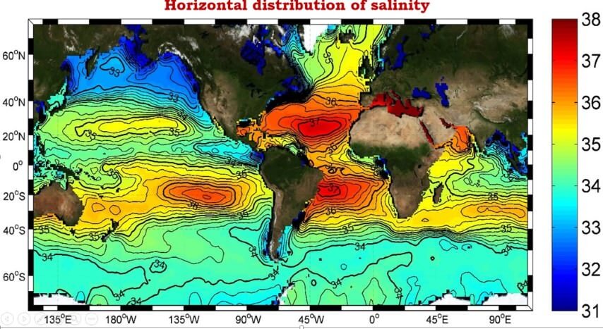
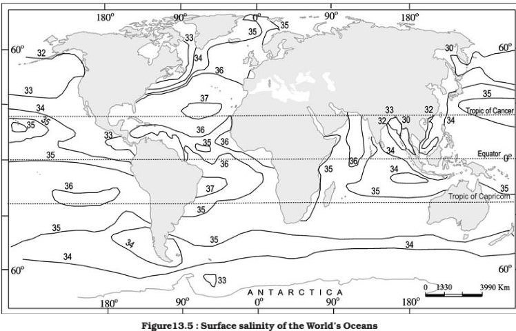
Horizontal distribution of salinity
To make life easier, I will remove the symbol o/oo and place only number
- The salinity for normal open ocean ranges between 33 and 37.
High salinity regions
- In the land locked Red Sea (don’t confuse this to Dead Sea which has much greater salinity), it is as high as 41.
- In hot and dry regions, where evaporation is high, the salinity sometimes reaches to 70.
Comparatively Low salinity regions
- In the estuaries (enclosed mouth of a river where fresh and saline water get mixed) and the Arctic, the salinity fluctuates from 0 – 35, seasonally (fresh water coming from ice caps).
Pacific
- The salinity variation in the Pacific Ocean is mainly due to its shape and larger areal extent.
Atlantic
- The average salinity of the Atlantic Ocean is around 36-37.
- The equatorial region of the Atlantic Ocean has a salinity of about 35.
- Near the equator, there is heavy rainfall, high relative humidity, cloudiness and calm air of the doldrums.
- The polar areas experience very little evaporation and receive large amounts of fresh water from the melting of ice. This leads to low levels of salinity, ranging between 20 and 32.
- Maximum salinity (37) is observed between 20° N and 30° N and 20° W – 60° W. It gradually decreases towards the north.
Indian Ocean
- The average salinity of the Indian Ocean is 35.
- The low salinity trend is observed in the Bay of Bengal due to influx of river water by the river Ganga.
- On the contrary, the Arabian Sea shows higher salinity due to high evaporation and low influx of fresh water.
Marginal seas
- The North Sea, in spite of its location in higher latitudes, records higher salinity due to more saline water brought by the North Atlantic Drift.
- Baltic Sea records low salinity due to influx of river waters in large quantity.
- The Mediterranean Sea records higher salinity due to high evaporation.
- Salinity is, however, very low in Black Sea due to enormous fresh water influx by rivers.
Inland seas and lakes
- The salinity of the inland Seas and lakes is very high because of the regular supply of salt by ‘ the rivers falling into them.
- Their water becomes progressively more saline due to evaporation.
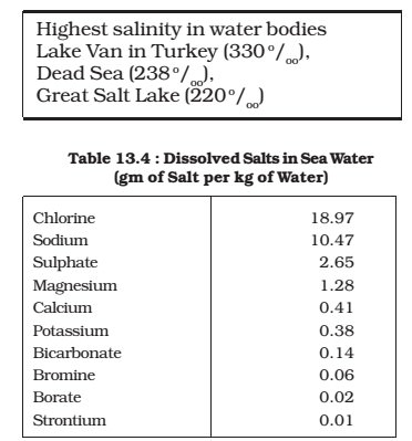
- For instance, the salinity of the Great Salt Lake , (Utah, USA), the Dead Sea and the Lake Van in Turkey is 220, 240 and 330 respectively.
- The oceans and salt lakes are becoming more salty as time goes on because the rivers dump more salt into them, while fresh water is lost due to evaporation.
Cold and warm water mixing zones
- Salinity decreases from 35 – 31 on the western parts of the northern hemisphere because of the influx of melted water from the Arctic region.
Sub-Surface Salinity
- With depth, the salinity also varies, but this variation again is subject to latitudinal difference. The decrease is also influenced by cold and warm currents.
- In high latitudes, salinity increases with depth. In the middle latitudes, it increases up to 35 metres and then it decreases. At the equator, surface salinity is lower.
Vertical Distribution of Salinity
- Salinity changes with depth, but the way it changes depends upon the location of the sea.
- Salinity at the surface increases by the loss of water to ice or evaporation, or decreased by the input of fresh waters, such as from the rivers.
- Salinity at depth is very much fixed, because there is no way that water is ‘lost’, or the salt is ‘added.’ There is a marked difference in the salinity between the surface zones and the deep zones of the oceans.
- The lower salinity water rests above the higher salinity dense water.
- Salinity, generally, increases with depth and there is a distinct zone called the halocline (compare this with thermocline), where salinity increases sharply.
- Other factors being constant, increasing salinity of seawater causes its density to increase. High salinity seawater, generally, sinks below the lower salinity water. This leads to stratification by salinity.


Comments
Post a Comment