(Unit 2-Topic 3) Western Ghats & Eastern Ghats of India
Indian Geography (Unit 2-Topic 3)
Western Ghats & Eastern Ghats of India
States and Union Territories under Western Ghats
Western Ghats are spread in six states viz. Gujarat, Maharashtra, Goa, Karnataka, Tamil Nadu, Kerala and two Union Territories viz. Dadra & Nagar Haveli and Pondicherry. The range starts near the border of Gujarat south of Tapti river where foothills of the ranges are occupying the eastern portion of Dadra and Silvassa in D&N. Running around 1600 kilometers down south, it ends at its southern part at Anamudi peak in Kerala. Mahe in Pondicherry is situated on the Malabar coast on the Western Ghats surrounded by Kerala
Mountains
Western Ghats are known as Sahyadri in northern Maharashtra, Sahya Parvatam in Kerala and Nilagiri Malai in Tamil Nadu. Western Ghats are home to many hill stations like Matheran, Lonavala-Khandala, Mahabaleshwar, Panchgani, Amboli Ghat, Kudremukh and Kodagu.
The extreme northern parts of Western Ghats falls in the Dangs district of Gujarat, known for Dang (Bamboo) forests. The confluence of the Eastern and the Western Ghats is at Biligirirangan Hills in Karnataka. Anamudi 2,695 metres in Kerala the highest peak in Western Ghats. Mullayanagiri is the highest peak in Karnataka 1,950 meters. The smaller ranges of the Western Ghats include the Cardamom Hills and the Nilgiri Hills. Cardamom hills are located in southeast Kerala and southwest Tamil Nadu. They conjoin the Anaimalai Hills to the northwest, the Palni Hills to the northeast and the Agasthyamalai Hills to the south as far as the Ariankavu pass. The crest of the hills forms the boundary between Kerala and Tamil Nadu. Anamudi is also located in Cardamom Hills. The Nilgiri Hills are home to the hill station Ooty.
There are many important passes in Western Ghats such as Tamhini Ghat, Palakkad Gap, Naneghat, Kasara ghat etc.
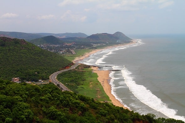
The northern portion of the narrow coastal plain between the Western Ghats and the Arabian Sea is known as the Konkan Coast, the central portion is called Kanara and the southern portion is called Malabar region or the Malabar Coast. The foothill region east of the Ghats in Maharashtra is known as Desh, while the eastern foothills of the central Karnataka state is known as Malenadu.
Geology
There are two views regarding the Geology of the Western Ghats. One view says the mountains of the Western Ghats are Block Mountains formed due to the down warping of a part of land into the Arabian Sea. Other view says that the mountains of the Western Ghats are not true mountains, but are the faulted edge of the Deccan Plateau. Major rocks found in the region include Basalt, charnockites, granite gneiss, khondalites, leptynites, metamorphic gneisses with detached occurrences of crystalline limestone, iron ore, dolerites and anorthosites.
Rivers
The rivers that originate in Western Ghats and flow towards west are Periyar, Bharathappuzha, Netravati, Sharavathi, Mandovi etc. The west flowing rivers of Western Ghats are fast-moving, owing to the short distance travelled and steeper gradient. This makes Western Ghats more useful than Eastern Ghats in terms of production of hydroelectricity. The steep gradient makes the Jog Falls on Shravasthi River in Karnataka as one of the most spectacular waterfalls in India. Narmada and Tapti although don’t rise from Western Ghats but flow westwards.
The rivers that originate in Western Ghats and flow towards east include three major rivers viz. Godavari, Krishna and Kaveri, and many smaller / tributary rivers such as Tunga, Bhadra, Bhima, Malaprabha, Ghataprabha, Hemavathi, Kabini. These east flowing rivers are comparatively slower moving and eventually merge into larger rivers such as the Kaveri and Krishna.
Climate
In comparison to the eastern side, the western side of the Western Ghats is area of high rainfall because the mountains intercept the rain-bearing westerly monsoon winds. The dense forests also contribute to high orographic precipitation. The climate is humid and tropical in the lower reaches tempered by the proximity to the sea. Elevations of 1,500 m and above in the north and 2,000 m and above in the south have a more temperate climate. Average annual temperature here is around 15 °C. In some parts frost is common, and temperatures touch the freezing point during the winter months. Mean temperature range from 20 °C in the south to 24 °C in the north. It has also been observed that the coldest periods in the south Western Ghats coincide with the wettest.
During the monsoon season between June and September, the unbroken Western Ghats chain acts as a barrier to the moisture laden clouds. The heavy, eastward-moving rain-bearing clouds are forced to rise and in the process deposit most of their rain on the windward side. Rainfall in this region averages 3,000–4,000 mm. The eastern region of the Western Ghats which lie in the rain shadow, receive far less rainfall averaging about 1,000 mm bringing the average rainfall figure to 2,500 mm.
Vegetation
Due to a sharp contrast in precipitation between western and eastern slopes of the Western Ghats, there is a clear difference between the vegetation of the two sides. Similarly, there is also a clear contrast between the northern and southern Western Ghats. Moreover, the vegetation found on the high hills is also different from the low hills. Thus, there are various different kinds of vegetations found in Western Ghats as follows:
- The western slopes have tropical and subtropical moist broadleaf forests marked predominantly by Rosewood, Mahogany, Cedar etc. These slopes appear green in almost all parts of the year. No time is fixed when these trees would shade their leaves.
- The eastern slopes of the Western Ghats have dry as well as moist deciduous forestsmarked predominantly by Teak, Sal, Shisham, Sandalwood etc. trees.
- Further, on the northern side of the Wayanad forests; we find dry deciduous forests while on the southern side there are wet deciduous forests. The evergreen Wayanad forests of Kerala mark the transition zone between the northern and southern ecoregions of the Western Ghats. The southern ecoregions are generally wetter and more species-rich. South Western Ghats Montane rain forests are the most species-rich ecoregions in peninsular India. Eighty percent of the flowering plant species of the entire Western Ghats range are found in this ecoregion.
- The areas which are high in elevation are cooler and wetter in the north and so the forests there are called North Western Ghats Montane rain forests. The vegetation here is evergreen characterized by trees of family Lauraceae. Such plants include Litsea glutinosa or Maida lakriin Hindi (a plant of medicinal value), Cinnamomum (Tejpatta) etc.
- There are montane grasslands as well as stunted forests also in the Western Ghats.
- The forest in the Western Ghats has been severely affected due to human activities, especially clear felling for tea, coffee, and teak plantations during 1860 to 1950. Species that are rare, endemic and habitat specialists are more adversely affected and tend to be lost faster than other species. Complex and species rich habitats like the tropical rainforest are much more adversely affected than other habitats. The area is ecologically sensitive to development. Though this area covers barely five percent of India’s land, 27% of all species of higher plants in India (4,000 of 15,000 species) are found here. Almost 1,800 of these are endemic to the region.
Protected Areas
Western Ghats is home to India’s two biosphere reserves, 13 National parks, several wildlife sanctuaries and many Reserve Forests. The Nilgiri Biosphere Reserve comprising 5500 km² of the evergreen forests of Nagarahole, deciduous forests of Bandipur National Park and Nugu in Karnataka and adjoining regions of Wayanad and Mudumalai National Park in the states of Kerala and Tamil Nadu forms the largest contiguous protected area in the Western Ghats. The Silent Valley National Park in Kerala is among the last tracts of virgin tropical evergreen forest in India.
Fauna
There are two biodiversity hotspots in our country viz. Eastern Himalayas and Western Ghats. Western Ghats are home to over 5000 species of flowering plants, 139 mammal species, 508 bird species and 179 amphibian species, many undiscovered species lives.
Following four species are endemic to Western Ghats.
- Malabar Large-spotted Civet
- Lion-tailed Macaque
- Brown Palm Civet
- Nilgiri Tahr
Malabar Large-spotted Civet is a critically endangered nocturnal mammal. The Lion-tailed Macaque is endangered and is arboreal (lives on trees). Only 2500 members of this species are remaining. The largest population of Lion Tailed Macaque is in Silent Valley National Park. Kudremukh National Park also protects a viable population. Nilgiri tahr is a goat antelope found high up in the mountains of southern India, it is known locally as the ‘Nilgiri ibex’. Its largest population is found within the Eravikulam National Park. Outside breeding seasons, males are found lower down in the best grazing fields, whilst female herds are found on the exposed cliff ledges. It has been classified as Endangered (EN) on the IUCN Red List. The brown palm civet’s distribution extends from the southern tip of Western Ghats in Kalakkad Mundanthurai Tiger Reserve to Castle Rock in Goa to the north. They are nocturnal, and not as rare as previously thought and come under Least Concerned Category.
These hill ranges serve as important wildlife corridors, allowing seasonal migration of endangered Asian Elephants. The Nilgiri Bio-sphere is home to the largest population of Asian Elephants and forms an important Project Elephant and Project Tiger reserve. Brahmagiri and Pushpagiri wildlife sanctuaries are important elephant habitats. Karnataka’s Ghat areas hold over six thousand elephants (as of 2004) and ten percent of India’s critically endangered tiger population.
_________________________________________________________________________________
Eastern Ghats of India
Eastern Ghats of India
The Eastern Ghats also known as Purva Ghat in Hindi, it is entirely different from the Western Ghats, because a western hat is the continuous range of scarp lands and the Eastern Ghats are mostly absent on the scrap areas.
On the Eastern Ghats, there are the different type of scarp areas, which nearly absent here. The range is cut up into a number separate Circum-denudational hills.
In the Orissa state, it found in many regions as only compact of mountainous. In the Eastern Ghats, there are many famous rivers have cut gaps through the Eastern Ghats and have separately broken its continuity.
The Eastern Ghats found in a state of Orissa, Maha Nandi, Godavari and Krishna have cut holes through the Eastern Ghats and have completely broken its continuity.
The mountains of Eastern Ghats are much more away from the sea as compare to the Western Ghats.
In the state of Orissa, the eastern Ghats mostly founded in the section of northern.
The northernmost past is called Simulia hills, the highest peak being Meghsini, which is the 1162 meters or the seat of the clouds.
In the Eastern Ghats, the shape of the circum-denudational hill is circular, and the drainage is radial, which is ideal for the Eastern Ghats.
Apart from that, the valleys of Baitarani and Brahmani south-west of Simulia hills are fertile, broad and well drained.
There are also more population and rush, and between them, there are rugged hills and ranges of which the highest peak is Malayagiri, which is height by 1138 meters.
The Mahanadi River cuts deep gorges through the ranges. Its middle portion around Hirakud dam and reservoir is more open. South-west of Mahanadi the mountains are higher.
Features of the Eastern Ghats
- It Stretches from Sundarbans to Kanyakumari
- It is comparatively wider
- It divided into Coromandel coast and North Sircar coastal plains
- The Deltas formed in this coastal stretch
- Influenced by north east monsoons
- They are lower and highest peak in the Eastern Ghats is Mahendragiri with a height of 1500 m.
- They rise gently from the east coast
- The hills are discontinuous
- The rivers cut valleys through the Eastern Ghats
- It is between Eastern Ghats and Bay of Bengal
In fact, they contain five of the highest peaks of the Eastern Ghats. Here is the highest peak of Orissa, Deomali, having an elevation of 1670 meters. Around Koraput, the hills in this area are flat topped.
In the southern tail of Orissa, Mahendragiri peak is 1500 meters high. The Ghat continuous along Orissa and Andhra Pradesh up to the gorge of Godavari at Bhadrachalam.
Here are the hills of Chandragiri and Pottangi. Compared to the Maliya range, the Madugula Konda have high elevation levels.
Here the highest peaks are Arma Konda (1680 meters), which followed by Gali Konda (1643 meters) and Sinkram Gutta (1620 meters).
Between Godavari and Krishna, the Eastern Ghat is not very prominent. They mainly formed by ancient sedimentary deposits of Cuddapah age.
They can be very well viewed from the railway train while travelling from Bellary to Guntur.
The ridges are sharp and rugged.
The whole hilly area has a crescent shape.
Near the northern tip of the bow, the Krishna across the hills in a deep incised double meander in the form of an S, just below the famous temple of Srisailam.
Here the height is 915 meters.
River Penner cuts across the crescent in the middle.
At the southern tip of the bow, there is massive sandstone hills rising step by step to the temple of Tirupati situated at the height of 1150 meters.
South of Palar the Eastern Ghat is much eroded and broken up in some circum-denudational hills such as Javadi, Shevaroy and Kalrayan.
Of them, Shevaroy reaches the maximum height of 1628 meters.
The Eastern Ghats may be supposed to end in Palni Hills, south of Kaveri, which flows in a rocky terrain near Srirangam.
The highest peak of Palni is Nilakottai, which is 1350 meters.


Comments
Post a Comment