(Unit 1-Topic 1) About India
Indian Geography (Unit 1)
Content :
- Latitudes and Longitudes
- Standard Time and Time Zones
- India and its neighbourhood-relations
- Indian States and Union Territories
_________________________________________________________________________________
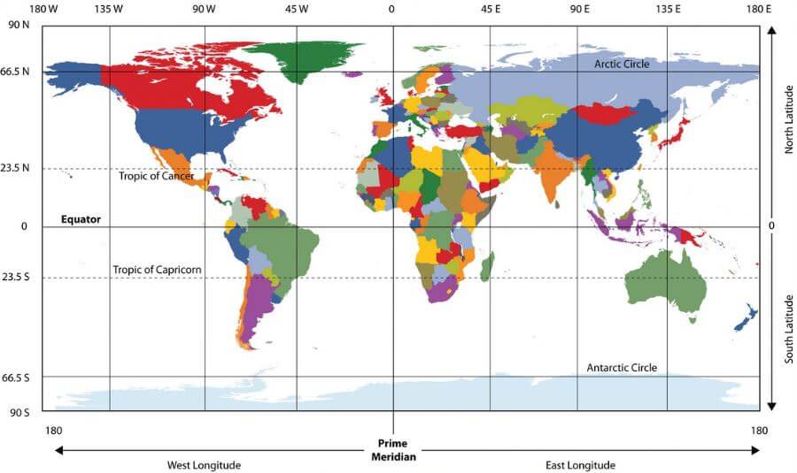
1. Latitudes and Longitudes
- Latitudes and Longitudes are imaginary lines used to determine the location of a place on earth.
- The shape of the earth is ‘Geoid’. And the location of a place on the earth can be mentioned in terms of latitudes and longitudes.
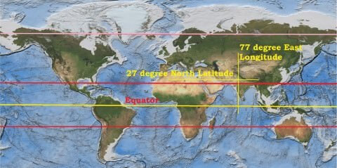
- Example: The location of New Delhi is 28° N, 77° E.
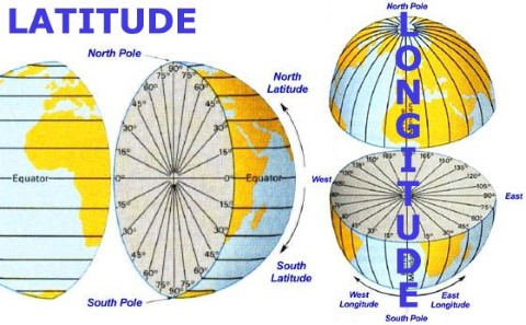
Latitude
- Latitude is the angular distance of a point on the earth’s surface, measured in degrees from the center of the earth.
- As the earth is slightly flattened at the poles, the linear distance of a degree of latitude at the pole is a little longer than that at the equator.
- For example at the equator (0°) it is 68.704 miles, at 45° it is 69.054 miles and at the poles it is 69.407 miles. The average is taken as 69 miles (111km).
- 1 mile = 1.607 km.
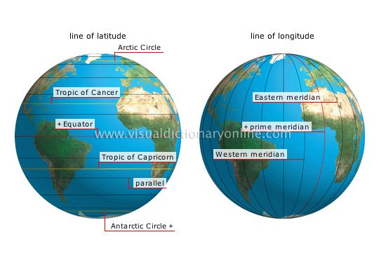
Important parallels of latitudes
- Besides the equator (0°), the north pole (90°N) and the south pole (90° S), there are four important parallels of latitudes–
- Tropic of Cancer (23½° N) in the northern hemisphere.
- Tropic of Capricorn (23½° S) in the southern hemisphere.
- Arctic circle at 66½° north of the equator.
- Antarctic circle at 66½° south of the equator.
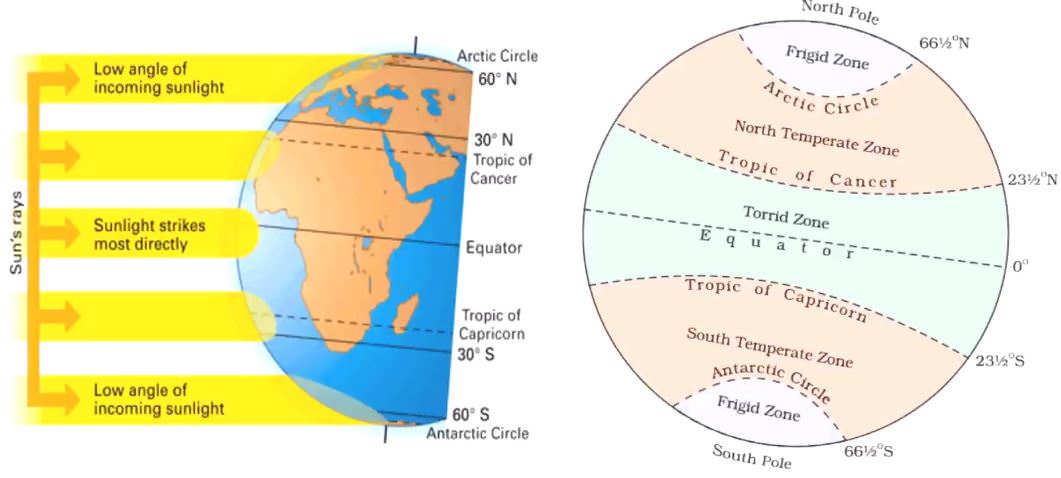
Latitudinal Heat zones of the earth
- The mid-day sun is exactly overhead at least once a year on all latitudes in between the Tropic of Cancer and the Tropic of Capricorn. This area, therefore, receives the maximum heat and is called the torrid zone.
- The mid-day sun never shines overhead on any latitude beyond the Tropic of Cancer and the Tropic of Capricorn. The angle of the sun’s rays goes on decreasing towards the poles. As such, the areas bounded by the Tropic of Cancer and the Arctic circle in the northern hemisphere, and the Tropic of Capricorn and the Antarctic circle in the southern hemisphere, have moderate temperatures. These are, therefore, called temperate zones.
- Areas lying between the Arctic circle and the north pole in the northern hemisphere and the Antarctic circle and the south pole in the southern hemisphere, are very cold. It is because here the sun does not raise much above the horizon. Therefore, its rays are always slanting. These are, therefore, called frigid zones.
Longitude
- Longitude is an angular distance, measured in degrees along the equator east or west of the Prime (or First) Meridian.
- On the globe longitude is shown as a series of semi-circles that run from pole to pole passing through the equator. Such lines are also called
- Unlike the equator which is centrally placed between the poles, any meridian could have been taken to begin the numbering of longitude. It was finally decided in 1884, by international agreement, to choose as the zero meridian the one which passes through the Royal Astronomical Observatory at Greenwich, near London.
- This is the Prime Meridian (0°) from which all other meridians radiate eastwards and westwards up to 180°.
- As the parallels of latitude become shorter poleward, so the meridians of longitude, which converge at the poles, enclose a narrower space.
- They have one very important function, they determine local time in relation to G.M.T. or Greenwich Mean Time, which is sometimes referred to as World Time.
Longitude and Time
- Since the earth makes one complete revolution of 360° in one day or 24 hours, it passes through 15° in one hour or 1° in 4 minutes.
- The earth rotates from west to east, so every 15° we go eastwards, local time is advanced by 1 hour. Conversely, if we go westwards, local time is retarded by 1 hour.
- We may thus conclude that places east of Greenwich see the sun earlier and gain time, whereas places west of Greenwich see the sun later and lose time.
- If we know G.M.T., to find local time, we merely have to add or subtract the difference in the number of hours from the given longitude.
________________________________________________________________________________
2. Standard Time and Time Zones
- If each town were to keep the time of its own meridian, there would be much difference in local time between one town and the other.
- Travelers going from one end of the country to the other would have to keep changing their watches if they wanted to keep their appointments. This is impractical and very inconvenient.
- To avoid all these difficulties, a system of standard time is observed by all countries.
- Most countries adopt their standard time from the central meridian of their countries.
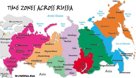
- In larger countries such as Canada, U.S.A., China, and U.S.S.R, it would be inconvenient to have single time zone. So these countries have multiple time zones.
- Both Canada and U.S.A. have five time zones—the Atlantic, Eastern, Central, Mountain and Pacific Time Zones. The difference between the local time of the Atlantic and Pacific coasts is nearly five hours.
- S.S.R had eleven time zones before its disintegration. Russia now has nine time zones.
The International Date Line
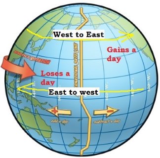
- A traveler going eastwards gains time from Greenwich until he reaches the meridian 180°E, when he will be 12 hours ahead of G.M.T.
- Similarly in going westwards, he loses 12 hours when he reaches 180°W. There is thus a total difference of 24 hours or a whole day between the two sides of the 180° meridian.
- This is the International Date Line where the date changes by exactly one day when it is crossed. A traveler crossing the date line from east to west loses a day (because of the loss in time he has made); and while crossing the dateline from west to east he gains a day (because of the gain in time he encountered).
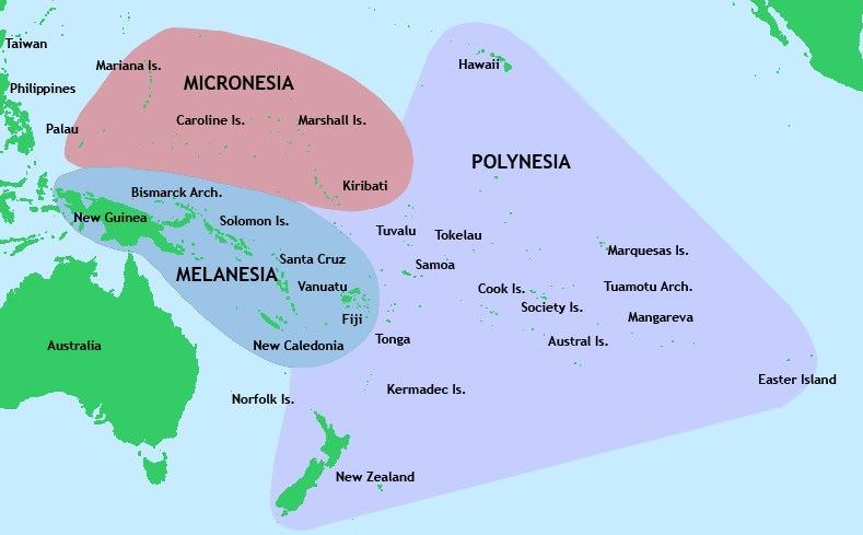
- The International Date Line in the mid-Pacific curves from the normal 180° meridian at the Bering Strait, Fiji, Tonga and other islands to prevent confusion of day and date in some of the island groups that are cut through by the meridian.
- Some of them keep Asiatic or New Zealand standard time, others follow the American date and time.
Why is the international dateline drawn in a zigzag manner?
- The International Date Line (IDL) passes through the Pacific Ocean. It is an imaginary line, like longitudes and latitudes.
- The time difference on either side of this line is 24 hours. So, the date changes as soon as one crosses this line.
- Some groups of Islands (Polynesia, Melanesia, Micronesia) fall on either of the dateline. So if the dateline was straight, then two regions of the same Island Country or Island group would fall under different date zones. Thus to avoid any confusion of date, this line is drawn through where the sea lies and not land. Hence, the IDL is drawn in a zig-zag manner.
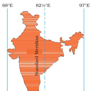
Indian Standard Time
- The Indian Government has accepted the meridian of 82.5° east for the standard time which is 5 hours 30 mins, ahead of Greenwich Mean Time.
Chaibagaan Time
- 150 years ago British colonialists introduced “chaibagaan time” or “bagaan time”, a time schedule observed by tea planters, which was one hour ahead of IST.
- This was done to improve productivity by optimizing the usage of daytime.
- After Independence, Assam, along with the rest of India, has been following IST for the past 66 years.
- The administration of the Indian state of Assam now wants to change it’s time zone back to Chaibagaan time to conserve energy and improve productivity.
- Indian government didn’t accept to such a proposal.
________________________________________________________________________
3. India and its neighbourhood-relations
India is land where people believe in cooperation and maintain healthy relationship with its neighbour. India has always been known as a “peace-loving country”. India has official political relations with most nations. India is considered as the world's second most populous and democratic country. Its economy is the fastest growing around the world. With the world's eighth largest military expenditure, third largest armed force, seventh largest economy by nominal rates and third largest economy in terms of purchasing power parity. India is a regional power, an embryonic global power and has capability to become superpower. India has a developing international influence and a prominent voice in global businesses.
India is a progressing industrialised nation. It has a history of partnership with several countries, is a component of the BRICS and a major part of developing world. India was one of the founding members of several international organisations, most notably the United Nations, the Asian Development Bank, G-20 major economies and the founder of the Non-Aligned Movement. India has also played an important and influential role in other international organisations like East Asia Summit, World Trade Organisation, International Monetary Fund (IMF), G8+5 and IBSA Dialogue Forum. Locally, India is a part of SAARC and BIMSTEC.
Foreign policy of India has always regarded the concept of neighbourhood as one of broadening concentric circles, around a central axis of historical and cultural commonalities. Millions people of Indian origin, live and work abroad and constitute an important link with the mother country. An important role of India's foreign policy has been to guarantee their welfare and wellbeing within the framework of the laws of the country where they live.
The Ministry of External Affairs is the Indian government's agency look after the foreign relations of India. The Minister of External Affairs holds cabinet rank as a member of the Council of Ministers. Sushma Swaraj is current Minister of External Affairs. When reviewing historical approach, India's international influence varied over the years after independence. Indian prestige and moral authority were high in the 1950s and enabled the acquisition of developmental assistance from both East and West. Although the prestige stemmed from India's nonaligned stance, the nation was incapable to prevent Cold War politics from becoming intertwined with interstate relations in South Asia.
In the decade of 1960 and 1970s, India's international position among developed and developing countries faded in the course of wars with China and Pakistan, disputes with other countries in South Asia, and India's effort to balance Pakistan's support from the United States and China by signing the Indo-Soviet Treaty of Friendship and Cooperation in August 1971. Although India obtained substantial Soviet military and economic aid, which helped to strengthen the nation, India's influence was undercut regionally and internationally by the perception that its friendship with the Soviet Union prevented a more forthright disapproval of the Soviet presence in Afghanistan. In the late 1980s, India developed relations with the United States, other developed countries, and China while continuing close ties with the Soviet Union. Relations with its South Asian neighbours, especially Pakistan, Sri Lanka, and Nepal, occupied much of the energies of the Ministry of External Affairs.
In the mid-1990s, India fascinated the world attention towards the terrorism supported by Pakistan in Kashmir. The Kargil War resulted in a major diplomatic victory for India. The United States and European Union recognised the fact that Pakistani military had illegally infiltrated into Indian Territory and pressured Pakistan to withdraw from Kargil. Several anti-India militant groups based in Pakistan were labelled as terrorist groups by the United States and European Union.
After disastrous terrorist attack in September 11 in 2001, Indian intelligence agencies provided the U.S. with significant information on Al-Qaeda and related groups' activities in Pakistan and Afghanistan. India's extensive contribution to the War on Terror, along with a surge in its economy, has assisted India's diplomatic relations with several countries.
India championed the cause of peace in the world. Being a large country, India has a long border and many neighbours with them have traditionally maintained welcoming and good neighbourly relations. Countries nearby India include Afghanistan, Bhutan, Bangladesh, China, Pakistan, Burma, Sri Lanka, Maldives, Bhutan, and Nepal. These neighbourhood countries are the member countries of the South Asian Association for Regional Cooperation (SAARC). The constituent countries individually as well as collectively represent a world of historical links, shared legacies, commonalities as well as diversities which are elaborately reflected in their ethnic, linguistic, religious and political fabric. China and Myanmar, the other two neighbours, are no less complex.
The South Asian region is also full of inconsistencies, disparities and paradoxes. In the post-colonial period, the South Asia has been a theatre of blood spattered interstate as well as civil wars. It has witnessed liberation movements, nuclear rivalry, military dictatorships and continues to suffer from insurgencies, religious fundamentalism and terrorism, besides serious problems associated with drugs and human trafficking.
The South Asian Association for Regional Cooperation (SAARC) has remained in existence for over two decades, yet South Asia is considered as the least integrated of the global regions. This is despite the stipulation in its Charter that "bilateral and contentious issues shall be excluded” from its deliberations, thus making it possible to put the contentious issues on the back burner and focus on areas of possible cooperation. On the positive side, the region has been registering good growth during the past several years. Also democratic forms of governance are beginning to gain some ground in most parts of the region.
India’s position is unique in its neighbourhood. As a matter of geographic factor, India shares borders with all other South Asian nations whereas no other South Asian nation (except Afghanistan and Pakistan) shares borders with any other South Asian nation. Notwithstanding some inadequacies, democracy and rule of law as instruments of political governance are well engrained in India. Transfer of power has been more or less peaceful and transparent. In relative terms, India can be debatably considered as the most stable country in the region, progressing at speedy rate, even though the growth has of late slowed down. In terms of its population, territory, GDP, its image as an evolving world economy and a responsible de-facto nuclear State, and as a country which is intended to play vital role at international stage.
Effect of pollutant on plants (Source: Rao, 1989)

India has many achievements. But, in the regional perspective, there is neighbours’ bitterness. There are unfair and erroneous perceptions about India floating around in the region. India treats its neighbours as an ignored courtyard. There are vested interests and lobbies for whom being anti-Indian is synonymous with being patriot and nationalist. There are strong institutions within the framework of a more or less failed State in the neighbourhood (Pakistan) which would like to see relations with India in a state of perpetual suspension. India’s intentions are suspected even in cases of innocent proposals for economic cooperation which would lead to win-win situations.
Afghanistan:
India’s relations with Afghanistan are healthy and there is co-operation in economic, technical and cultural fields. India applauded the UN-sponsored Geneva Agreement on Afghanistan in 1988. India recapped its stand for an independent, non-aligned Afghanistan. Country realized that the Afghans themselves should be allowed to decide upon their future without external pressure. To maintain friendly relations, India provided Rs.10 crore assistance for relief and rehabilitation of Afghan refugees. India is also supporting Afghanistan in public health, small-scale industries, and education. Bilateral relations between India and Afghanistan have been customarily strong and pleasant. While India was the only South Asian country to identify the Soviet-backed Democratic Republic of Afghanistan in the 1980s. Its relations were weakened during the Afghan civil wars and the rule the Islamist Taliban in the 1990s. India assisted the rebellion of the Taliban and became the largest regional provider of humanitarian and reconstruction aid. The new constitutionally elected Afghan government strengthened its ties with India in wake of persisting tensions and problems with Pakistan, which is continuing to shelter and support the Taliban. India espoused a policy of cooperation to boost its standing as a regional power and contain its competitor Pakistan, which supports Islamic militants in Kashmir and other parts of India. India is the major regional investor in Afghanistan, having committed more than US$2.2 billion for rebuilding purposes.India offers aid programs for Afghanistan include infrastructure development, institutional capacity building, small development projects, as well as food security assistance in the form of ongoing deliveries of wheat to Afghanistan. Since 2001, more than 10,000 Afghan students have studied in India on ICCR scholarships, with approximately 7,000 returning home armed with an education and technical skills, which they are using to drive Afghanistan’s stabilization and development. In the meantime, many officers in the Afghan government have benefited from the technical capacity building programs of ITEC and the Indian Council of Agricultural Research, while some 8,000 Afghan students are pursuing self-financed degrees in different fields across India.
Despite many transit obstacles, the volume of Indo-Afghan trade stood at $680 million during 2013-2014, which is continually rising, following the full implementation of the Afghanistan and Pakistan Trade and Transit Agreement (APTTA). Furthermore, air connectivity between the two nations has grown progressively. There are four to five flights operating daily between Kabul and Delhi, bringing to India nearly 1,000 Afghans, many of them medical tourists, seeking treatment in Delhi hospitals.
To expand economic ties between the two nations, the Afghan Embassy in Delhi has frequently engaged with the national and local chambers of commerce and industries of India. The embassy has so far signed five memorandums of understanding (MOUs) covering commercial and medical cooperation between Afghanistan’s respective chambers of commerce and hospitals, while it has initiated another 20 MOUs with state chambers and hospitals across India among these few are in the coming months. Indian investors are more interested in the many “virgin markets” of Afghanistan, including mining, agriculture and agribusiness, information and technology, telecommunications, and others.
Furthermore, to strength relation between Afghans and Indians, the Afghan Embassy in Delhi has introduced the creation of sister-city relations between major Indian cities and states and their Afghan counterparts. Presently, the embassy has proposed the creation of relations between Delhi and Kabul, Mumbai and Kandahar, Ajmer Sharif (Rajasthan) and Herat, Hyderabad and Jalalabad, Ahmadabad (Gujrat) and Asadabad (Kunar), as well as the State of Assam and the Province of Helmand.
It can be assessed that India remains a vital part of Afghanistan’s stable progress in institutionalizing peace, pluralism, and prosperity. Links between Afghanistan and India go beyond the traditionally strong relations at the government level. Since ancient time, the peoples of Afghanistan and India have interacted with each other through trade and commerce, peacefully coexisting on the basis of their shared cultural values and commonalities. This history has become the foundation of mutual trust. Public opinion polls in Afghanistan confirm this, as well as the sentiment Afghans share about feeling at home whenever they visit India.
Bangladesh:
Indian government believe in maintaining good relations with neighbouring countries. Bangladesh is one of its close neighbour. India had recognised Bangladesh as a separate and independent state, did so on 6 December 1971. India fought together with the Bangladeshis to liberate Bangladesh from West Pakistan in 1971. Bangladesh and India share a common tradition. They are pleasant and both nations make great efforts to solve the problem of waters of Ganga at Farakka and Tin Bigha corridor in a spirit of give and take. India has helped Bangladesh in the recovery of cyclone victims in 1985. In broad sense, the relations between the two nations continue to be amiable. But major issues in relation with these two nation is that of about 145,000 Chakma refugees who crossed over to India. Bangladesh's relationship with India has been difficult in terms of irrigation and land border disputes post 1976. Nevertheless, India has maintained favourable relationship with Bangladesh during governments formed by the Awami League in 1972 and 1996. The solutions of land and maritime disputes have taken out nuisances in ties.At the beginning, India's relations with Bangladesh have not been stronger because of India's absolute support for independence and opposition against Pakistan in 1971. During the independence war, many refugees fled to India. When the struggle of resistance matured in November 1971, India also interfered militarily and has helped in bring international attention to the issue through Indira Gandhi's visit to Washington, D.C. Afterwards India furnished relief and reconstruction aid. India also withdrew its military from the land of Bangladesh when Sheikh Mujibur Rahman requested Indira Gandhi to do so during the latter's visit to Dhaka in 1972. Indo-Bangladesh relations have been somewhat less friendly since the fall of Mujib government in August 1975. But as the time passed, many issues emerged such as South Talpatti Island, the Tin Bigha Corridor and access to Nepal, the Farakka Barrage and water sharing, border conflicts near Tripura and the construction of a fence along most of the border which India explains as security provision against migrants, insurgents and terrorists. Bilateral relations began to friendly in 1996, due to soft Indian foreign policy and the new Awami League Government. A 30-year water-sharing agreement for the Ganges River was signed in December 1996, after an earlier bilateral water-sharing agreement for the Ganges River lapsed in 1988. Both nations also have cooperated on the issue of flood warning and readiness. The Bangladesh Government and tribal insurgents signed a peace accord in December 1997, which allowed for the return of tribal refugees who had escaped into India, beginning in 1986, to escape violence caused by an insurgency in their homeland in the Chittagong Hill Tracts. The Bangladesh Army maintains a very strong presence in the area presently. The army is progressively concerned about problem of cultivation of illegal drugs.
There are also small pieces of land along the border region that Bangladesh is tactfully trying to reclaim. Padua, part of Sylhet Division before 1971, has been under Indian control since the war in 1971. This small strip of land was re-occupied by the BDR in 2001, but later given back to India after Bangladesh government decided to solve the problem through diplomatic negotiations. The Indian New Moore Island no longer exists, but Bangladesh repeatedly claims it to be part of the Satkhira district of Bangladesh.
India has increasingly complained that Bangladesh does not secure its border well. It fears an increasing flow of poor Bangladeshis and it accuses Bangladesh of sheltering Indian separatist groups like ULFA and alleged terrorist groups. The Bangladesh government has snubbed to accept these allegations. India estimates that over 20 million Bangladeshis are living unlawfully in India. Since 2002, India has been building an India - Bangladesh Fence along much of the 2500 mile border. The failure to resolve migration disputes bears a human cost for illegal migrants, such as imprisonment and health risks, namely HIV/Aids. Presently, India’s Prime Minister Narendra Modi and his Bangladeshi counterpart Sheikh Hasina have completed a revolutionary deal redrawing their disordered shared border and there by solving disputes between India and Bangladesh. Bangladesh and India have signed a historic agreement to simplify their border by exchanging more than 150 enclaves of land.
Bangladesh also offer India transit route to travel through Bangladesh to its North East states. India and Bangladesh also have free trade agreement in June 7, 2015. Both nations solved its border dispute on June 6, 2015. To connect Kolkata with Tripura via Bangladesh through railway, the Union Government on 10 February 2016 sanctioned about 580 crore rupees. The funds were sanctioned for constructing the 15-kilometer railway track between Kolkata and Tripura. The project that is expected to be completed by 2017 will pass through Bangladesh. The Agartala-Akhaura rail-link between Indian Railway and Bangladesh Railway will reduce the current 1700 km road distance between Kolkata to Agartala via Siliguri to just 350-kilometer by railway. These projects are high level and on Prime Minister's 'Act East’ Policy, and is anticipated to increase connectivity and increase trade between India and Bangladesh.
Bhutan:
Relations between India and Bhutan are friendly since past and it is strengthened recently. Co-operation in economic field between the two countries has advanced them. India has helped Bhutan in industry development such as in the field of telecommunications, hydel survey, education and forestry. Historically, there have been strong ties with India. Both countries signed a friendship treaty in 1949, where India would support Bhutan in foreign relations. On 8th February 2007, the Indo-Bhutan Friendship Treaty was substantially revised under the Bhutanese King, Jigme Khesar Namgyel Wangchuck. Whereas in the Treaty of 1949 Article 2 read as "The Government of India undertakes to exercise no interference in the internal administration of Bhutan. On its part, the Government of Bhutan agrees to be guided by the advice of the Government of India in regard to its external relations." In the revised treaty, it is described as, "In keeping with the abiding ties of close friendship and cooperation between Bhutan and India, the Government of the Kingdom of Bhutan and the Government of the Republic of India shall cooperate closely with each other on issues relating to their national interests. Neither government shall allow the use of its territory for activities harmful to the national security and interest of the other". The revised treaty also includes in it the preamble.The Indo-Bhutan Friendship Treaty of 2007 supports Bhutan's position as an independent and sovereign nation. The hydropower sector is one of the main supports of bilateral cooperation. It demonstrates mutually beneficial synergy by providing clean energy to India and exports revenue to Bhutan (power contributes 14% to the Bhutanese GDP, comprising about 35% of Bhutan's total exports). Three hydroelectric projects (HEPs) totaling 1416 MW, (336 MW Chukha HEP, the 60 MW Kurichu HEP, and the 1020 MW Tala HEP), are already exporting electricity to India. In 2008, the both governments identified ten more projects for development with a total generation capacity of 10,000 MW. Of these, three projects totalling 2940 MW (1200 MW Punatsangchu-I, 1020 MW Punatsangchu-II and 720 MW Mangdechu HEPs) are under construction and are scheduled to be commissioned in the last quarter of 2017-2018. Out of the remaining 7 HEPs, 4 projects totalling 2120 MW (600 MW Kholongchhu, 180 MW Bunakha, 570 MW Wangchu and 770 MW Chamkarchu) will be constructed under Joint Venture model, for which a Framework Inter-Governmental Agreement was signed between both governments in 2014. Of these 4 JV-model projects, pre-construction activities for Kholongchhu HEP have commenced.
It is assessed that India continuously involved in business relations and development partner of Bhutan. Planned development efforts in Bhutan began in the early 1960s. The First Five Year Plan (FYP) of Bhutan was launched in 1961. Since then, India has been extending financial assistance to Bhutan’s FYPs. The 10th FYP ended in June 2013. India's overall help to the 10th FYP was a little over Rs.5000 crores, excluding grants for hydropower projects.
Burma/Myanmar:
India maintained political relations after Burma's independence from Great Britain in 1948. Burma is located to the south of the states of Mizoram, Manipur, Nagaland and Arunachal Pradesh in Northeast India and the proximity of the People's Republic of China gives strategic importance to Indo-Burmese relations. Since many years, Indo-Burmese relations were strong due to cultural links, prosperous commerce, common interests in regional affairs and the presence of a significant Indian community in Burma. Burma is one of the good neighbour with whom India shares a long and sensitive border. Relations between the two countries have been friendly. When serious turbulence erupted in Burma in 1988, India expressed sympathy for the democratic aspirations of the people in that country. Additionally, India allowed Burmese inhabitants to stay in camps in Mizoram and Arunachal Pradesh.India offered good support when Burma struggled with regional rebellions. However, the revolution of the democratic government by the Military of Burma led to strains in ties. India condemned the suppression of democracy and Burma ordered the exclusion of the Burmese Indian community, increasing its own isolation from the world. Only China maintained healthy relations with Burma while India supported the pro-democracy movement.
However, due to geo-political concerns, India revitalised its relations and acknowledged the military junta ruling Burma in 1993, overcoming strains over drug trafficking, the clampdown of democracy. The Indo-Burmese border stretches over 1,600 kilometres and some insurgents in North-east India seek refuge in Burma. Subsequently, Indian government is interested in military cooperation with Burma in its counter-insurgency activities.
In 2001, the Indian Army completed the construction of a major road along its border with Burma. India has also been building major roads, highways, ports and pipelines within Burma to increase its influence in the region and also to counter China's rising strides in the Indochina peninsula. Indian companies have also sought active participation in oil and natural gas exploration in Burma. In February 2007, India announced a plan to develop the Sittwe port, which enabled ocean access from Indian North-eastern states like Mizoram, via the Kaladan River.
India is a major purchaser of Burmese oil and gas. In 2007, Indian exports to Burma totalled US$185 million, while its imports from Burma were estimated US$810 million, consisting mostly of oil and gas. India has granted US$100 million credit to fund highway infrastructure projects in Burma, while US$57 million has been offered to advancement of Burmese railways. A further US$27 million grants was pledged for road and rail projects. India has also offered military assistance to the Burmese junta. Nonetheless, there has been increasing pressure on India to cut some of its military supplies to Burma. Relations between the two nations are healthy which was apparent in the outcome of Cyclone Nargis, when India provided relief and rescue aid proposals that were accepted by Burma's ruling junta.
China:
China is also close neighbour of India. The relation between these two nations are changeable. Though it is observed that India had traditionally friendly relation. In 1962, China invaded India and occupied huge areas. After that the relations between the two countries became strained. India always make efforts to improve relation with China. India wants good solution of the boundary issues. But China wants to delay solution to the border issue. With respect to the boundary disagreement, India’s has clear position. In 1988, former P.M. Rajiv Gandhi said that any solution to Indo-China boundary issue must be reasonable not only to the two government but also to the people of the two countries. Rajiv Gandhi’s visit to China in December 1988 was considered as beginning in the relations between the two nations. It was sensed that a favourable climate and condition should be created for good solution to the issues between two nations. Chinese P.M. Li Peng also visited to India in December 1991and helped to develop good understanding. However co-operation and exchange of delegations in areas like culture, sports and trade has been resumed, but the boundary issue remained to be sorted out.In spite of persistent suspicions remaining from the 1962 Sino-Indian War and continuing boundary disputes over Aksai Chin and Arunachal Pradesh, Sino-Indian relations have improved progressively since 1988. Both countries have sought to reduce tensions along the frontier, swell trade and cultural ties, and normalise relations.
In both nation, high-level delegates and ministers regularly visit. Such efforts have helped to improve relations. In December 1996, PRC President Jiang Zemin visited India during a tour of South Asia. While in New Delhi, he signed with the Indian Prime Minister a series of confidence-building measures for the disputed borders. Sino-Indian relations suffered a brief setback in May 1998 when the Indian Defence minister justified the country's nuclear tests by citing potential threats from the PRC. Nevertheless, in June 1999, during the Kargil crisis, then-External Affairs Minister Jaswant Singh visited Beijing and stated that India did not consider China a threat. By 2001, relations between India and the PRC were improved, and both nations handled the move from Tibet to India of the 17th Karmapa in January 2000 with delicacy and tact. In 2003, India formally accepted Tibet as a part of China, and China recognised Sikkim as an official part of India in 2004.
Since 2004, the economic growth of China and India has also helped furnace closer relations. Sino-Indian trade reached US$65.47 billion in 2013-14, making China the single largest trading partner of India. The growing economic reliance between India and China has also bought the two nations closer administratively, with both India and China excited to resolve their boundary dispute. They have also worked together on several issues ranging from WTO's Doha round in 2008 to regional free trade agreement. Alike Indo-US nuclear deal, India and China have also agreed to cooperate in the field of civilian nuclear energy. Though, China's economic interests have conflicted with those of India.
Indian government always tries to improve relations with Islamabad and the PM has developed an excellent relationship with the Chinese leadership “The Prime Minister has particularly developed an excellent relationship even with the Chinese leadership. India has a boundary issue with them. And the boundary issue is unresolved. There are other several issues related to China, which are of our concern. But at least the tense situation around the boundary does not exist.
Maldives:
India has retained cordial relations with Maldives. Maldives is located south of India's Lakshadweep Islands in the Indian Ocean. As friendly neighbours, India and Maldives share ethnic, linguistic, cultural, religious and commercial links steeped in antiquity and enjoy cordial and multi-dimensional relations. Indian troops landed in Maley in November 1988 and saved Maldivian hostages who had been detained in a coup. Maldives has been guaranteed by India of its full support and assistance in the economic growth.India has considerable influence over Maldives' foreign policy and offers extensive security co-operation especially after the Operation Cactus in 1988 during which India repelled Tamil mercenaries who occupied the country.
As a founder member in 1985 of the South Asian Association for Regional Cooperation, SAARC, which brings together Afghanistan, Bangladesh, Bhutan, India, Maldives, Nepal, Pakistan and Sri Lanka, India has vital role in SAARC. The Maldives has taken the lead in calling for a South Asian Free Trade Agreement, the formulation of a Social Charter, the initiation of informal political consultations in SAARC forums, the lobbying for greater action on environmental issues, the proposal of several human rights measures such as the regional convention on child rights and for setting up a SAARC Human Rights Resource Centre. The Maldives also promotes greater international profile for SAARC such as through formulating common positions at the UN.
India and Maldives signed a trade agreement in 1981, which provides for export of vital commodities. Indian exports to the Maldives include agriculture and poultry produce, sugar, fruits, vegetables, spices, rice, wheat flour (Atta), textiles, drugs and medicines, a variety of engineering and industrial products, sand and aggregate, cement for building etc. Indian imports primarily scrap metals from the Maldives. Under the bilateral agreement, India offers essential food items like rice, wheat flour, sugar, dal, onion, potato and eggs and construction material such as sand and stone aggregates to Maldives on favourable terms.
India has begun the process to bring the island country into India's security grid. The move comes after the moderate Islamic nation approached New Delhi earlier over fears that one of its island resorts could be taken over by terrorists given its lack of military assets and surveillance capabilities. India also signed an agreement with the Maldives in 2011 which focuses on the following factors:
India shall permanently base two helicopters in the country to improve its surveillance capabilities and ability to respond swiftly to threats. One helicopter from the Coast Guard was handed over during A. K. Antony's visit while another from the Navy will be cleared for transfer shortly.
Maldives has coastal radars on only two of its 26 atolls. India will support set up radars on all 26 for seamless coverage of approaching vessels and aircraft.
The coastal radar chain in Maldives will be networked with the Indian coastal radar system. India has already undertaken a project to install radars along its entire coastline. The radar chains of the two nations will be interlinked and a central control room in India's Coastal Command will get a seamless radar picture.
The Indian Coast Guard (ICG) will perform regular Dornier sorties over the island nation to look out for suspicious movements or vessels. The Southern Naval Command will facilitate the inclusion of Maldives into the Indian security grid.
Military teams from Maldives will visit the tri-services Andaman & Nicobar Command (ANC) to observe how India manages security and surveillance of the critical island chain.
Nepal:
Nepal is also friendly neighbour country of India. There has been a long tradition of free movement of people across the borders. Nepal has an area of 147,181 sq. kms and a population of 29 million. It shares a border of over 1850 kms in the east, south and west with five Indian States – Sikkim, West Bengal, Bihar, Uttar Pradesh and Uttarakhand and in the north with the Tibet Autonomous Region of the People's Republic of China. Relations between India and Nepal are strong though there are some troubles stemming from border disputes, geography, economics, and the problems in-built in big power-small power relations, and common ethnic and linguistic identities that overlap the two countries' borders. Mainly relation between India and Nepal are based on century’s traditional cultural ties. India has supported a lot to Nepal in its development projects. The trade and transit treaty issue created some differences between the two neighbours. But the issue has since been resolved. Fortunately, these two neighbours have always good understanding on disputed matters and they resolve intelligently.In 1950 New Delhi and Kathmandu introduced their intertwined relationship with the Treaty of Peace and Friendship and accompanying secret letters that defined security relations between the two countries, and an agreement governing both bilateral trade and trade transiting Indian land. According to the 1950 treaty and letters, "neither government shall tolerate any threat to the security of the other by a foreign aggressor" and obligated both sides "to inform each other of any serious friction or misunderstanding with any neighbouring state likely to cause any breach in the friendly relations subsisting between the two governments", and also granted the Indian and Nepali people’s right to get involved in any economic activity such as work and business related activity in each other's region. Such treaties solidified relationship between India and Nepal that granted Nepalese in India the same economic and educational opportunities as Indian inhabitants.
Relations between India and Nepal weakened during 1989 when India imposed a 13-month-long economic barrier of Nepal. But Indian PM Narendra Modi visited Nepal in 2014 and normalized relations. This clearly indicates that the Modi government wants to maintain affable bilateral ties with the Nepalese government. According to news report, “Prime Minister Narendra Modi wound up his "historic" visit to Nepal with a slew of sops focusing on the 4 Cs cooperation, connectivity, culture and constitution to enhance bilateral ties.”
There are regular exchanges of senior leader’s visits and interactions between India and Nepal. Nepalese Prime Minister Shri Sushil Koirala visited India to attend the swearing-in ceremony of Prime Minister Shri Narendra Modi on 26 May 2014. In 2014, Prime Minister Shri Narendra Modi visited Nepal twice, in August for a bilateral visit and in November for the SAARC Summit, during which several bilateral agreements were signed. India and Nepal have several bilateral institutional dialogue mechanisms, including the India-Nepal Joint Commission co-chaired by External Affairs Minister of India and Foreign Minister of Nepal.
In devastating earthquake occurred in Nepal on 25 April 2015, the Government of India swiftly dispatched National Disaster Response Force (NDRF) teams and special aircrafts with rescue and relief materials to Nepal.
In 2015, a blockade of the India-Nepal border has effected relations. The barrier is led by ethnic communities annoyed by Nepal's recently promulgated new constitution. However, the Nepalese government blamed India of deliberately worsening the embargo, but India denies these allegations.
On political front, with the commencement of the 12-Point understanding reached between the Seven Party Alliance and the Maoists at Delhi in November 2005, Government of India has applauded the roadmap laid down by the historic Comprehensive Peace Agreement of November 2006 towards political stabilization in Nepal, through peaceful reconciliation and inclusive democratic processes. India has steadily responded with a sense of urgency to the needs of the people and Government of Nepal in ensuring the success of the peace process and institutionalization of multiparty democracy through the framing of a new Constitution by a duly elected Constituent Assembly. India work on the policy that only an inclusive Constitution with the broadest possible consensus by taking on board all stakeholders would result in durable peace and stability in Nepal. India’s major interest in Nepal is a united Nepal’s peace and stability which has a bearing on India as well because of the long and open border shared between India and Nepal.
India and Nepal has strong economic ties also. Since 1996, Nepal’s exports to India have grown rapidly and bilateral trade more than seven times. The main items of exports from India to Nepal are petroleum products, motor vehicles and spare parts, billets, machinery and spares, medicines, hot rolled sheets, wires, coal, cement, threads and chemicals. The main items of exports from Nepal to India are polyester yarn, textiles, jute goods, threads, zinc sheet, packaged juice, cardamom, G.I. pipe, copper wire, shoes and sandals, stones and sand. Indian firms hugely invested in Nepal. There are approximately 150 operating Indian ventures in Nepal involved in manufacturing, services (banking, insurance, dry port, education and telecom), power sector and tourism industries. Some big Indian investors include ITC, Dabur India, Hindustan Unilever, VSNL, TCIL, MTNL, State Bank of India, Punjab National Bank, Life Insurance Corporation of India, Asian Paints, CONCOR, GMR India, IL&FS, Manipal Group, MIT Group Holdings, Nupur International, Transworld Group, Patel Engineering, Bhilwara Energy, Bhushan Group, Feedback Ventures, RJ Corp, KSK Energy, Berger Paints, Essel Infra Project Ltd. and Tata Power.
Government of India offers significant financial and technical development assistance to Nepal, which is a broad-based programme focusing on creation of infrastructure at the grass-root level, under which various projects have been implemented in the fields of infrastructure, health, water resources, education and rural & community development. Recently, India has been assisting Nepal in development of border infrastructure through development of roads in the Terai areas. Development of cross-border rail links at Jogbani–Biratnagar, Jaynagar-Bardibas, Nepalgunj Road-Nepalgunj, Nautanwa-Bhairhawa, and New Jalpaigudi-Kakarbhitta; and establishment of Integrated Check Posts at Raxaul-Birgunj, Sunauli-Bhairhawa, Jogbani-Biratnagar, and Nepalgunj Road-Nepalgunj.
India has also helped Nepal in the field of education and prove to be best neighbour. India’s contribution to the development of human resources in Nepal has been one of the major aspects of bilateral cooperation.
In cultural arena, Government of India initiatives to promote people-to-people contacts in the area of art & culture, academics and media include cultural programmes, symposia and events organized in partnership with different local bodies of Nepal, as well as conferences and seminars in Hindi. Assistance is also provided to several India-Nepal Friendship Organizations working to promote Indian culture and India-Nepal bilateral relations.
Pakistan:
Pakistan has been antagonistic when maintaining relations with India. But India has made extreme efforts to improve and stabilize relations with Pakistan. Pakistan has been buying arms from the USA. From Indian viewpoint, it would create tension in the region. Reports indicated that Pakistan assist and conduct training for terrorists in Punjab and Kashmir. Pakistan has been raising the Kashmir issue on various international media. India has conveyed its concern to Pakistan over all these issues. India has assured Pakistan that it would never attack Pakistan, but the actions of Pakistan are conflicting to the ideologies of bilateralism enshrined in the Simla Agreement. Thus the relations between India and Pakistan are bitter.Though there are historical, cultural and ethnic links between them, relations between India and Pakistan have been afflicted by years of distrust ever since the partition of India in 1947. Major cause of dispute between India and Pakistan has been the Kashmir conflict. After an invasion by Pashtun tribesmen and Pakistani paramilitary forces, the Hindu Maharaja of the Dogra Kingdom of Jammu and Kashmir, Hari Singh, and its Muslim Prime Minister, Sheikh Abdullah, signed an Instrument of Accession with New Delhi. The First Kashmir War started after the Indian Army entered Srinagar, the capital of the state, to secure the area from the occupying forces. The war ended in December 1948 with the Line of Control dividing the erstwhile princely state into territories administered by Pakistan and India. Pakistan challenged the legality of the Instrument of Accession since the Dogra Kingdom has signed a standstill agreement with it. The Indo-Pakistani War of 1965 began following the failure of Pakistan's Operation Gibraltar, which was designed to infiltrate forces into Jammu and Kashmir to precipitate an insurgency against rule by India. This five-week war took thousands of human life on both sides. It ended in a United Nations (UN) instructed ceasefire and the successive issuance of the Tashkent Declaration. In 1971, India and Pakistan went to war again. This time the conflict being over East Pakistan. The large-scale atrocities committed there by the Pakistan army led to millions of Bengali refugees entering into India. India, along with the Mukti Bahini, overpowered Pakistan and the Pakistani forces surrendered on the eastern front. The war resulted in the creation of Bangladesh.
In 1998, India performed the Pokhran-II nuclear tests which was followed by Pakistan's Chagai-I tests. Following the Lahore Declaration in February 1999, relations between two nations slightly improved. A few months later, Pakistani paramilitary forces and Pakistan Army, penetrated in huge numbers into the Kargil district of Indian Kashmir. This started the Kargil War after India moved in thousands of troops to successfully kick out the infiltrators. Although the conflict did not result in a full-scale war between India and Pakistan, relations between the two nations again worsened even further following the involvement of Pakistan-based terrorists in the hijacking of the Indian Airlines Flight 814 in December 1999. India again tried to make friendly relations and came forward to organize the Agra summit held in July 2001, but it also failed. Some devastating events, an attack on the Indian Parliament in December 2001, which was blamed on Pakistan. This resulted in military standoff between the two countries which lasted for nearly a year raising fears of a nuclear warfare. However, a peace process, started in 2003, led to improved relations in the following years.
To begin the peace process, several confidence-building-measures (CBMs) between India and Pakistan have been taken. The Samjhauta Express and Delhi-Lahore Bus service are two of these successful measures which had played vital role to expand people-to-people contact between the two countries. The initiation of Srinagar-Muzaffarabad Bus service in 2005 and opening of a historic trade route across the Line of Control in 2008 augment keenness between the two sides to improve relations.
The 2008 Mumbai assaults seriously destabilised the relations between the two countries. India alleged Pakistan of harbouring militants on their land, while Pakistan fervently denies such claims.
Sri Lanka:
India and Sri Lanka has conventionally close to each other. Huge numbers of Tamil of Indian origin live in Sri Lanka. This created cultural problem in Sri Lanka. Although the problem of the people of Indian origin settled in Sri Lanka was solved by P.M. Lal Bahadur Shastri in a friendly manner, but the killings of the Tamil in that country worsen the relations between the two countries. With the signing of Indo-Sri Lanka Accord in 1987 relations improved. The Indian Peace-keeping Forces have returned to India after having performed their job. Assassination of Rajiv Gandhi by LTTE activities put the relations between the two countries in melancholies.Though bilateral relations between Sri Lanka and India have been generally pleasant, but were affected by the Sri Lankan Civil War and by the failure of Indian intervention during the civil war as well as India's support for Tamil Tiger militants. India is Sri Lanka's only neighbour, separated by the Palk Strait. Both nations occupy a strategic position in South Asia and have sought to build a common security authority in the Indian Ocean.
Over the years, India-Sri Lanka relations have undergone major transformation. Political relations are close, trade and investments have increased radically, infrastructural linkages are continually being increased, defence collaboration has increased and there is broad-based improvement across all sectors of bilateral cooperation. India was the first nation to respond to Sri Lanka's request for assistance after the tsunami in December 2004. In July 2006, India evacuated 430 Sri Lankan nationals from Lebanon, first to Cyprus by Indian Navy ships and then to Delhi and Colombo by special Air India flights.
Political relations are built through high-level exchanges of visits. Prof. G.L.P eiris, Minister of External Affairs of Sri Lanka visited India for the eighth meeting of the India-Sri Lanka Joint Commission which was held on 22 January 2013. Former President of India, Dr. A.P.J. Abdul Kalam visited Sri Lanka from 20-24 January 2012 to launch the ‘National Plan for a Trilingual Sri Lanka’, at the invitation of the President of Sri Lanka.
There is an agreement within the Sri Lankan polity on the importance of India in Sri Lanka's external relations matrix. Both the major political parties in Sri Lanka, the Sri Lanka Freedom Party and the United Nationalist Party have contributed to the rapid development of bilateral relations in the last many years. Sri Lanka has supported India's contention to the permanent membership of the UN Security Council.
News report have shown that from being in the middle of a disturbed neighbourhood, under the leadership of Prime Minister Narendra Modi, India’s relations with its neighbours have improved.
India and Sri Lanka has also close commercial relations. India and Sri Lanka has good trade and investment relationship, with bilateral trade growing speedily in last decade and a numerous big Indian private sector companies investing in Sri Lanka and establishing a presence in this country. Sri Lanka is India's largest trade partner in South Asia. India in turn is Sri Lanka's largest trade partner globally. Trade between the two countries grew particularly rapidly after the entry into force of the India-Sri Lanka Free Trade Agreement in March 2000.
It is assessed that both nations have built upon an inheritance of intellectual, cultural, religious and linguistic intercourse. Relations between the two countries have also matured and diversified with the passage of time, encompassing all areas of contemporary relevance. Recently, the relationship has been marked by close contacts at the highest political level, growing trade and investment, cooperation in the fields of development, education, culture and defence, as well as a broad understanding on major issues of international interest.
To summarize, India is a huge country with manifold cultures. It has high status in the South East Asia. India has vast cultural advancement therefore nation has maintained good and sociable relations with all its neighbours. India’s foreign policy is to maintain peace, freedom and mutual co-operation among the nations. Its foreign policy is based on the philosophies of Panchsheela, nonalignment disarmament. India’s immediate neighbours are Sri Lanka, Pakistan, Bangladesh, Nepal, Bhutan, Maldives, Burma, China and Afghanistan. India has cordial historical, religious, economic, ethnic and linguistic relationships with all of these states. Preferably, India would prefer a peaceful, wealthy neighbourhood responsive to its own needs and wishes. But from the outset of its history as an independent country, India’s major challenges have included the promotion of internal cohesion and the management of its often troubled relations with its neighbouring countries, the two often being closely linked, for example in relation to Pakistan, Nepal and Sri Lanka. In India, political leaders and populace always look forward for friendly relationship with neighbouring countries, though many conflicts emerged in past.
________________________________________________________________________

________________________________________________________________________
4. Indian States and Union Territories
At the time of reorganization of Indian states, India had 14 states and 6 union territories but as of now on Feb 2016, India has 29 states and 7 union territories. These all states are different with each other in terms of languages, climate, religion, customs, dressing and cousines etc. But still India is called the union of states. Just because of the diversity at each step and intact togetherness made India an excellent example of unity in diversity. Here in this single article jagran josh is providing a plethora of information on all the states of India.
Top 10 Largest States of India in Terms of Area
In the light of the vision of Pandit Nehru, India is divided in five Zonal Councils as per Part-III of the States Re-organisation Act, 1956. Present composition of each of these Zonal Councils is as under:
1. The Northern Zonal Council
2. The Central Zonal Council
3. The Eastern Zonal Council
4. The Western Zonal Council
5. The Southern Zonal Council
1. The Northern Zonal Council: The North zone council comprises some states like Haryana, Himachal Pradesh, Jammu & Kashmir, Punjab, Rajasthan, National Capital Territory of Delhi and Union Territory of Chandigarh.
(a) Haryana is the 20th state of India that came into being on 1st November 1966. It is called the land of Battlefield of India. Presently it has 21 districts. Previously it was under Punjab. It is situated in the North Western region surrounded by Himachal Pradesh from North, Uttrakhand from North East, Rajasthan from the South, U.P and Delhi from East and Punjab from North West. Haryana has the lowest sex ration n the whole country at 877.
(b) Himachal Pradesh is (known as "Devabhoomi", the abode of the Gods) a state in Northern India. Its area is 21,495 sq mt. it was founded in January 25, 1971, with capital at Shimla covers the Area of 55,673 km⊃2; with population of 68.65 Lakh.
(c) Jammu & Kashmir has special autonomy under Article 370 of the Constitution of India. It is the first state of India which has its own flag and constitution. It became part of Indian Territory when its ruler maharaja Hari Singh accepted the sovereignty of India on 26 Oct, 1947.
(d) Punjab is located in the north west of India, is one of the most prosperous states of India.The word Punjab is derived from the Persian words Panj ("five") and Āb ("waters"), thus Panjāb means "Five Rivers", which roughly means "Land of Five Rivers" such as Sutlej, Beas, Ravi, Chenab and Jhelum.
(e) Rajasthan is India's largest state by area (342,239 km2 (132,139 sq mi) or 10.4% of India's total area). It is located on the western side of the country, where it comprises most of the wide and inhospitable Thar Desert (also known as the "Rajasthan Desert" and "Great Indian Desert").
(f) National Capital Territory of Delhi is the capital city of India. It is historically and culturally connected to both the Upper Doab of the Yamuna-Ganges river system and the Punjab region. It is bordered by Haryana on three sides and by Uttar Pradesh to the east. It has a population of about 16.75 million, making it the second most populous city and second most populous urban agglomeration in India and 3rd largest urban area in the world.
(g) Union Territory of Chandigarh is a city and a union territory in the northern part of India that serves as the capital of the states of Punjab and Haryana. As a union territory, the city is ruled directly by the Union Government and is not part of either state. It is a union territory since 1966.
2. The Central Zonal Council: Central Zonal Council comprises states like: Chhattisgarh, Uttarakhand, Uttar Pradesh and Madhya Pradesh.
(a) Chhattisgarh was formed on 1 November 2000 by partitioning 16 Chhattisgarhi-speaking southeastern districts of Madhya Pradesh. Chhattisgarh is a state in central India. It is the 10th largest state in India, with an area of 135,194 km2 (52,199 sq mi) and with a population of 25.5 million.
(b) Uttarakhand was formed on 9th November 2000 as the 27th State of India, when it was carved out of northern Uttar Pradesh. It is located at the foothills of the Himalayan mountain ranges. The four most sacred and revered Hindu temples of Badrinath,Kedarnath, Gangotri and Yamunotri are nestled in this state. It’s truly God’s Land (Dev Bhoomi).
(c) Uttar Pradesh is biggest state of India (in terms of population). Its area of 2,36,286 km2 lies between latitude 24 deg to 31 deg and longitude 77 deg to 84 deg East. It is the largest producer of sugarcane, sugar, wheat and potato in the whole country.
(d) Madhya Pradesh is situated in the central region of India and that’s why it is called the Heartland State. It has the largest reserves of diamond and copper in India as Madhya Pradesh is rich in mineral resources. It came into existence in 1956. It is the largest producer of Soyabean in the country.
3. The Eastern Zonal Council: The Eastern Zonal Council comprises states like: Bihar, Jharkhand, Odisha, West Bengal and Sikkim.
(a) Bihar is located in the eastern part of the country (between 83°-30' to 88°-00' longitude). It is an entirely land–locked state, although the outlet to the sea through the port of Kolkata is not far away. It was established in 26 Jan., 1950. As per census 2011, it is most dense state of India.
(b) Jharkhand is a state in eastern India carved out of the southern part of Bihar on 15 November 2000. It has an area of 79,710 km2 (30,778 sq mi). The city of Ranchi is its capital while the industrial city of Jamshedpur is the largest in the state. It is the top producer of iron ore, copper ore, kainite, mica and uranium (Jaduguda mines, Narwa Pahar).
(c) Odisha has 485 kilometres (301 mi) of coastline along the Bay of Bengal on its east, from Balasore to Ganjam. Odia (formerly known as Oriya) is the official and most widely-spoken language. It is the biggest producer of manganese in India.
(d) West Bengal is a state in eastern India and is the nation's fourth-most populous state, with over 91 million inhabitants. Spread over 34,267 sq mi (88,750 km2), it is bordered by the countries of Bangladesh, Nepal and Bhutan, and the Indian states of Odisha, Jharkhand, Bihar, Sikkim, and Assam. The state capital is Kolkata. This state is most famous for Royal Bengal Tiger in Sundarvan.
4. The Western Zonal Council: The Western Zonal Council comprises of states like: Goa, Gujarat, Maharashtra and the Union Territories of Daman & Diu and Dadra & Nagar Haveli
(a) Goa is bounded by the state of Maharashtra to the North and by Karnataka to the East and South, while the Arabian Sea forms its western coast. It is India's smallest state by area and the fourth smallest by population. Goa is India's richest state. It was established on 30 may, 1987.
(b) Gujarat is a state in the western part of India, known locally as Jewel of the Western part of India. It has an area of 196,204 km2 (75,755 sq mi) with a coastline of 1,600 km (990 mi), most of which lies on the Kathiawar peninsula, and a population in excess of 60 million. It is best known for the Asiatic lion. It has the biggest coast line in India.
(c) Maharashtra is a state spanning west-central India, is best known for its fast-paced capital, Mumbai (formerly Bombay). This sprawling metropolis is the seat of the Bollywood film industry. It’s also famed for sites like the British Raj-era Gateway of India monument and the cave temples at nearby Elephanta Island. It was established in 1st May 1960.
(d) Union Territories of Daman & Diu, for over 450 years, the coastal enclaves of Daman and Diu on the Arabian Sea coast were part of Portuguese India, along with Goa and Dadra and Nagar Haveli. Goa, Daman and Diu were incorporated into the Republic of India on December 19, 1961, by military conquest.
(e) Dadra & Nagar Haveli is a Union Territory in Western India. Nagar Haveli is wedged between Maharashtra and Gujarat, whereas Dadra is an enclave 1 km NW, surrounded by Gujarat. The shared capital is Silvassa. The larger part spans a roughly c-shaped area up-river from the city of Daman on the coast, at the centre of which, and thus outside the territory, is the Madhuban reservoir. It came into existence on 11 Aug. 1961.
5. The Southern Zonal Council: The Southern Zonal Council comprises states like: Andhra Pradesh, Karnataka, Kerala, Tamil Nadu and the (e)Union Territory of Puducherry (f) Telangana
(a) Andhra Pradesh is situated on the southeastern coast of the country. The state is covering an area of 160,205 km2 (61,855 sq mi). On 2 June 2014, the North-Western portion of the state was bifurcated to form a new state of Telangana. Hyderabad will remain the de jure capital of both Andhra Pradesh and Telangana states for not exceeding 10 years. It is called the Rice bowl of India.
(b) Karnataka is a state in south western region of India. It was formed on 1 November 1956, with the passage of the States Reorganisation Act. Originally known as the State of Mysore, it was renamed Karnataka in 1973. The capital and largest city is Bangalore/ Bangaluru is known as the silicon valley of India. It is also known as the land of sun rising Industry.
(c) Kerala is historically known as Keralam, is a state in South India on the Malabar Coast. It was formed on 1 November 1956 following the States Reorganisation Act by combining various Malayalam-speaking regions, spread over 38,863 km2 (15,005 sq mi). It is the largest Rubber producer state of India most educated state of India and a state of highest sex ration in the country.
(d) Tamil Nadu is literally The Land of Tamils or Tamil Country. Tamil Nadu,lies in the southernmost part of the Indian Peninsula and is bordered by the union territory of Puducherry and the South Indian states of Kerala, Karnataka, and Andhra Pradesh. Tamil Nadu is the second largest state economy in India with (US$ 167.172 billion) in Gross Domestic Product.
(e) Union Territory of Puducherry formerly known as Pondicherry literally New Town in Tamil is a Union Territory of India. It was formed out of four exclaves of former French India namely Puducherry, Karaikal, Yanam and Mahe. It is named after the largest district Puducherry. The territory changed its official name to Puducherry on 20 September 2006. it was formed on 1st November 1966.
(f) Telangana is a state in South India and one of the 29 states in India. It was formed on 2 June 2014 with the city of Hyderabad as its capital. Telangana is bordered by the states of Maharashtra to the north and North west, Chhattisgarh to the North. Telangana has an area of 114,840 square kilometres (44,340 sq mi), and a population of 35,193,978 (2011 census. Currently its capital is Hyderabad.


Comments
Post a Comment